Fraud Blocker Skip to main content

Home > Asia > Vietnam > Maps

Maps Collection

Maps of Vietnam Asia are detailed maps that show the physical and political features of the country

Choose a picture from our Maps Collection for your Wall Art and Photo Gifts

56 items

Background imageMaps Collection: Asia map 1875

Asia map 1875
The Independent Course Comprehensive Geography by James Monteith, A.S. Barnes & Co, New York & Chicago 1875

Background imageMaps Collection: Vietnam / Map C1930 French

Vietnam / Map C1930 French
Card produced when La Cochinchine was a French colony

Background imageMaps Collection: Vietnam country map

Vietnam country map
2011 edition

Background imageMaps Collection: Map of Vietnam

Map of Vietnam

Background imageMaps Collection: Antique map of Vietnam, Laos, Cambodia and Ta'hailand

Antique map of Vietnam, Laos, Cambodia and Ta'hailand
Antique map of Vietnam, Laos, Cambodia and TÔǽhailand

Background imageMaps Collection: Map of Thailand and Vietnam 1900

Map of Thailand and Vietnam 1900
Meyers hand-Atlas Leipzig und Wien Verlag des Bibliographischen Instituts 1900

Background imageMaps Collection: Map of Farther India, 1902. Creator: Unknown

Map of Farther India, 1902. Creator: Unknown
Map of Farther India, 1902. Southeast Asia, including Burma, Siam, Cambodia, French Indochina and Malaya. From The Century Atlas of the World. [John Walker & Co, Ltd. London, 1902]

Background imageMaps Collection: Vietnam, Relief Map with Border and Mask

Vietnam, Relief Map with Border and Mask
Relief map of Vietnam (with border and mask). This image was compiled from data acquired by landsat 5 & 7 satellites combined with elevation data

Background imageMaps Collection: SAIGON

SAIGON
StudioSix

Background imageMaps Collection: Map of Tonkin, Annam, Cochinchine (coloured engraving)

Map of Tonkin, Annam, Cochinchine (coloured engraving)
8651484 Map of Tonkin, Annam, Cochinchine (coloured engraving) by French School, (19th century) (after); Private Collection; (add.info.: Map of Tonkin, Annam, Cochinchine)

Background imageMaps Collection: 1 Maps 3 35

1 Maps 3 35
Emiliano Deificus

Background imageMaps Collection: Vietnam Reference Map

Vietnam Reference Map

Background imageMaps Collection: Antique map Burma, Thailand, Vietnam, Malaysia, 1897, late 19th Century

Antique map Burma, Thailand, Vietnam, Malaysia, 1897, late 19th Century
Vintage engraving of a Antique map of Burma, Thailand, Vietnam, Malaysia, 1897, late 19th Century

Background imageMaps Collection: antique, archival, border, burma, cambodia, cartography, country, document, geography

antique, archival, border, burma, cambodia, cartography, country, document, geography, historic, historical, india orientalis, indian ocean, indonesia, islands, latitude, legend, longitude, malaysia

Background imageMaps Collection: Map of Asia 1877

Map of Asia 1877
Warrens Common School Geography 1877

Background imageMaps Collection: 13825076

13825076

Background imageMaps Collection: Old Antique map of Farther India, Burma, Siam, Malay, Vietnam, 1890s, Victorian 19th Century history

Old Antique map of Farther India, Burma, Siam, Malay, Vietnam, 1890s, Victorian 19th Century history
Antique map of Farther India, Burma, Siam, Malay, Vietnam, 1890s, Victorian 19th Century history

Background imageMaps Collection: French school textbook map of Indochina, 1905 (colour litho)

French school textbook map of Indochina, 1905 (colour litho)
CHT216702 French school textbook map of Indochina, 1905 (colour litho) by French School, (20th century); Private Collection; eArchives Charmet; French, out of copyright

Background imageMaps Collection: Field Headquarters of General Navarre, General Cogny and Colonel de Castries

Field Headquarters of General Navarre, General Cogny and Colonel de Castries
PNP316654 Field Headquarters of General Navarre, General Cogny and Colonel de Castries, Dien Bien Phu, Northwest Vietnam in 1954 (b/w photo) by French Photographer

Background imageMaps Collection: Indochina (chromolitho)

Indochina (chromolitho)
1094316 Indochina (chromolitho) by French School, (19th century); Private Collection; (add.info.: Indochina. French educational card, late 19th or early 20th century.); © Look and Learn

Background imageMaps Collection: Ms HM 2182 Maps made during the voyage of a Vietnamese embassy to China (w / c on paper)

Ms HM 2182 Maps made during the voyage of a Vietnamese embassy to China (w / c on paper)
CHT216716 Ms HM 2182 Maps made during the voyage of a Vietnamese embassy to China (w/c on paper) by Vietnamese School (18th century); Societe Asiatique, College de France, Paris

Background imageMaps Collection: Plan of Bacninh with its Environs (engraving)

Plan of Bacninh with its Environs (engraving)
1622462 Plan of Bacninh with its Environs (engraving) by English School, (19th century); Private Collection; (add.info.: Plan of Bacninh with its Environs)

Background imageMaps Collection: MS HM 2182 The Forbidden City in Peking, from a collection of maps made during a

MS HM 2182 The Forbidden City in Peking, from a collection of maps made during a
CHT216715 MS HM 2182 The Forbidden City in Peking, from a collection of maps made during a Vietnamese embassy to China (w/c on paper) by Vietnamese School (18th century); Societe Asiatique

Background imageMaps Collection: Map of East India (South and Southeast Asia: Pakistan, India, Nepal, Bangladesh, Burma

Map of East India (South and Southeast Asia: Pakistan, India, Nepal, Bangladesh, Burma
LRI4710618 Map of East India (South and Southeast Asia: Pakistan, India, Nepal, Bangladesh, Burma, Sri Lanka, Thailand, Malaysia, Vietnam, Cambodia, Laos, Philipines)

Background imageMaps Collection: Douglas A-26B Invader N84W

Douglas A-26B Invader N84W
Douglas A-26B-61-DL Invader N84W (msn 27834) of Rodman Supply Co, Odessa, TX. Delivered to l Armee de l Air as , 3 January 1951 to 1955 based in Indochina

Background imageMaps Collection: 616098852

616098852
Maps, 616098852

Background imageMaps Collection: Annamese chiefs and women, Vietnam, 1895

Annamese chiefs and women, Vietnam, 1895. From The Universal Geography with Illustrations and Maps, division XVI, written by Elisee Reclus and published by Virtue & Co. Limited (London, 1895)

Background imageMaps Collection: Cambojan, eldest son of Narodom, 1895. Artist: Charles Barbant

Cambojan, eldest son of Narodom, 1895. Artist: Charles Barbant
Cambojan, eldest son of Narodom, 1895. From The Universal Geography with Illustrations and Maps, division XVI, written by Elisee Reclus and published by Virtue & Co. Limited (London, 1895)

Background imageMaps Collection: Boats on the Chinese Arroyo, near Saigon, Vietnam, 1895

Boats on the Chinese Arroyo, near Saigon, Vietnam, 1895. From The Universal Geography with Illustrations and Maps, division XV, written by Elisee Reclus and published by Virtue & Co

Background imageMaps Collection: Map of Asia 1895

Map of Asia 1895
The Rand-McNally Grammar School Geography 1895 - Chicago & New York

Background imageMaps Collection: Composite On North Vietnam

Composite On North Vietnam

Background imageMaps Collection: Vietnam locator map

Vietnam locator map
2012 edition

Background imageMaps Collection: Vietnam - Infographic map - illustration

Vietnam - Infographic map - illustration
Vector maps of Vietnam with variable specification and icons

Background imageMaps Collection: EVNT2A-00313

EVNT2A-00313
Map of the China Seas, Philippines, and European colonies in the region, 1898. Printed color lithograph 19th century

Background imageMaps Collection: Map of Asia 1889

Map of Asia 1889
Indiana Educational Series The Complete Geography - Indianapolis 1889

Background imageMaps Collection: Map of Asia 1889

Map of Asia 1889
Indiana Educational Series The Complete Geography - Indianapolis 1889

Background imageMaps Collection: Asia map 1881

Asia map 1881
Harpers School Geography, New York, Harpers and Brothers, 1881

Background imageMaps Collection: Asia map 1881

Asia map 1881
Harpers School Geography, New York, Harpers and Brothers, 1881

Background imageMaps Collection: Robert McNamara explain Vietnam War strategy, 1965

Robert McNamara explain Vietnam War strategy, 1965
A front page of The Illustrated London News, dated 13th February 1965, showing Secretary of Defense Robert McNamara(1916-2009) outlining the U.S strategy for the Vietnam War. Date: 1965

Background imageMaps Collection: Cover design, Fly to the East

Cover design, Fly to the East, showing destinations in India, Thailand, Vietnam, China, Singapore, Australia and Tasmania. 20th century

Background imageMaps Collection: 1842, Greenleaf Map of the East Indies, Borneo, Java, Sumatra, Thailand, Vietnam

1842, Greenleaf Map of the East Indies, Borneo, Java, Sumatra, Thailand, Vietnam

Background imageMaps Collection: 1837, Malte-Brun Map of India, Burma and Southeast Asia, Siam, Vietnam, topography

1837, Malte-Brun Map of India, Burma and Southeast Asia, Siam, Vietnam, topography
1837, Malte-Brun Map of India, Burma and Southeast Asia, Siam, Vietnam

Background imageMaps Collection: 1771, Bonne Map of Tonkin, Vietnam China, Formosa, Taiwan and Luzon, Philippines

1771, Bonne Map of Tonkin, Vietnam China, Formosa, Taiwan and Luzon, Philippines, Rigobert Bonne 1727 - 1794, one of the most important cartographers of the late 18th century

Background imageMaps Collection: Map of Asia 1883

Map of Asia 1883
Warrens Common School Geography

Background imageMaps Collection: ROBERT McNAMARA (1916-2009). American businessman and public official

ROBERT McNAMARA (1916-2009). American businessman and public official. As U.S. Secretary of Defense, pointing to a map of Indochina at a press conference in Washington, D.C. 26 April 1965

Background imageMaps Collection: China and Japan map 1875

China and Japan map 1875
The Independent Course Comprehensive Geography by James Monteith, A.S. Barnes & Co, New York & Chicago 1875

Background imageMaps Collection: Main research trips in Asia 1895

Main research trips in Asia 1895
Meyers Konversations-Lexikon. Ein Nachschlagewerk des allgemeinen Wissens, 5th edition 17 volumes Bibliographisches Institut - Leipzig 1895-1897

Background imageMaps Collection: Asia political map 1895

Asia political map 1895
Meyers Konversations-Lexikon. Ein Nachschlagewerk des allgemeinen Wissens, 5th edition 17 volumes Bibliographisches Institut - Leipzig 1895-1897


All Professionally Made to Order for Quick Shipping


-

Maps Collection

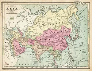
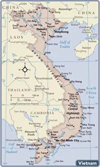
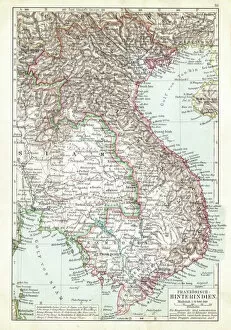
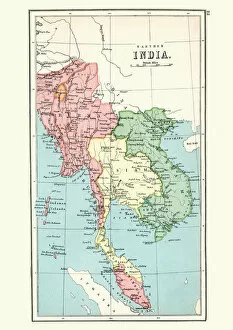
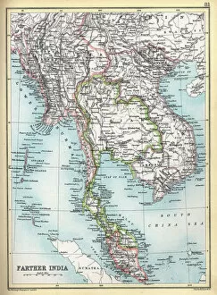
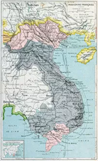
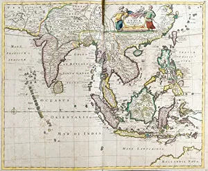
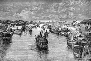
Maps of Vietnam Asia are detailed maps that show the physical and political features of the country. They include roads, rivers, cities, provinces and other geographical features. They also provide information about the population density of each region as well as its economic activities. Maps of Vietnam Asia are useful for travelers who want to explore the country or for those who need to plan their business trips. Additionally, they can be used by students studying geography or history in order to gain a better understanding of this diverse region. Maps of Vietnam Asia can be found online or in bookstores and provide an invaluable resource for anyone wanting to learn more about this fascinating part of the world.
+

Our beautiful pictures are available as Framed Prints, Photos, Wall Art and Photo Gifts

The Maps of Vietnam Asia collection from Media Storehouse is a stunning compilation of vintage and contemporary maps that showcase the beauty and diversity of Vietnam. Our collection features an array of maps, ranging from detailed topographical maps to colorful illustrated maps that depict the country's rich culture and history. The Maps of Vietnam Asia collection offers a unique perspective on this Southeast Asian nation, highlighting its natural wonders, bustling cities, and iconic landmarks. Each map in our collection is carefully curated by expert designers who ensure that every detail is captured with precision and accuracy. Whether you're looking for a beautiful piece of wall art or a framed print to display in your home or office, the Maps of Vietnam Asia collection has something for everyone. This stunning collection celebrates the beauty and complexity of Vietnam through intricate cartography that captures its essence like no other medium can.
+

What are Maps of Vietnam Asia art prints?

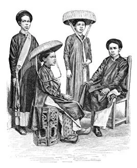
Maps of Vietnam Asia art prints are high-quality reproductions of vintage and contemporary maps that depict the geography, topography, and landmarks of Vietnam. These prints showcase the intricate details of the country's terrain, including its mountains, rivers, coastlines, cities, and towns. They also feature important historical sites such as temples, pagodas, and monuments. These art prints are perfect for anyone who loves travel or has a special connection to Vietnam. They can be used to decorate homes or offices with an Asian theme or as educational tools in schools and libraries. We offer a wide range of Maps of Vietnam Asia art prints in various sizes and formats to suit different preferences. You can choose from framed or unframed options depending on their needs. The company uses high-quality materials to ensure that each print is durable and long-lasting while maintaining its vibrant colors and sharp details over time.
+

What Maps of Vietnam Asia art prints can I buy from Media Storehouse?

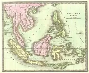
We offer a wide range of Maps of Vietnam Asia art prints that are perfect for those who love history, geography, and culture. These maps showcase the different regions of Vietnam and provide detailed information about its cities, towns, rivers, mountains, and other landmarks. You can choose from vintage or modern designs that come in various sizes to suit your preferences. Some popular options include the 1968 Map of South Vietnam during the Vietnam War which shows military bases and strategic locations; the 1890 Map of Tonkin (Northern Vietnam) with French annotations; and the 2017 Political Map of Southeast Asia which highlights neighboring countries such as Laos, Cambodia, Thailand, and China. Whether you're looking for educational materials or decorative pieces for your home or office space, we have something to offer. With their high-quality printing technology and excellent customer service support team available at all times to assist you with any questions or concerns regarding your purchase.
+

How do I buy Maps of Vietnam Asia art prints?

To purchase Maps of Vietnam Asia art prints from Media Storehouse, you can browse our extensive collection online and select the print that catches your eye. Once you have found the artwork you wish to buy, simply add it to your cart and proceed to checkout. At this point, you will be prompted to enter your payment details and shipping address. We offer a variety of sizes and framing options for their art prints, so be sure to choose the one that best suits your needs. They also provide high-quality printing on premium paper stock using archival inks, ensuring that your print will last for years without fading or deteriorating. Whether you are looking for a unique piece of wall decor or a gift for someone special, Maps of Vietnam Asia art prints from Media Storehouse are an excellent choice. With their vast selection of beautiful artwork and easy-to-use website, purchasing a stunning print has never been easier.
+

How much do Maps of Vietnam Asia art prints cost?

We offer a wide range of Maps of Vietnam Asia art prints at varying prices. Our collection includes vintage maps, modern interpretations, and artistic renditions of the region. The cost of each print depends on various factors such as size, framing options, and printing materials. We take pride in sourcing high-quality prints from reputable artists around the world to ensure that our customers receive only the best products. Our Maps of Vietnam Asia art prints are perfect for those who want to add an element of culture and history to their home or office decor. Whether you're looking for a small print to fit on your bookshelf or a large statement piece for your living room wall, we have something for everyone. We believe that art should be accessible to all, which is why we strive to offer affordable prices without compromising on quality.
+

How will my Maps of Vietnam Asia art prints be delivered to me?

We take pride in delivering your Maps of Vietnam Asia art prints with utmost care and efficiency. Your order will be processed promptly upon receipt and dispatched to you using our trusted delivery partners. We use high-quality packaging materials to ensure that your prints arrive in perfect condition. We offer a range of delivery options depending on your location and urgency of the order. Our standard delivery service is reliable and cost-effective, while express shipping is available for those who require their orders urgently. Once your order has been dispatched, we will provide you with tracking information so that you can monitor its progress until it arrives at your doorstep. If there are any issues or concerns with the delivery process, our friendly customer service team is always ready to assist you. Rest assured that when you purchase Maps of Vietnam Asia art prints from us, they will be delivered safely and securely to your chosen address.