Antique Framed Print > Maps and Charts > Americas
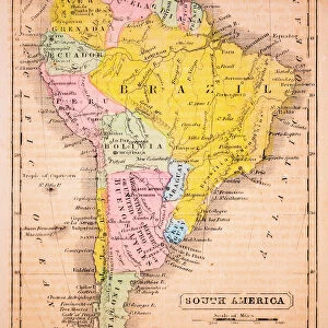
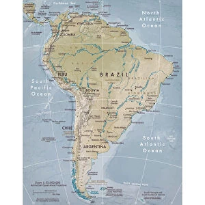
Antique Framed Print : Map Of South America, 1899


![]()
Framed Photos from Universal Images Group (UIG)
Map Of South America, 1899
Universal Images Group (UIG) manages distribution for many leading specialist agencies worldwide
Media ID 20165177
© Universal Images Group
1872 Engraving 1899 Heir Nineteenth Century Map South America Wandering
14"x12" (36x31cm) Antique Frame
Bevelled wood effect frame, card mounted, 10x8 archival quality photo print. Overall outside dimensions 14x12 inches (36x31cm). Environmentally and ozone friendly, the Polycore® moulding has the look of real wood, is durable and light and easy to hang. Biodegradable and made with non-chlorinated gases (no toxic fumes) it is efficient; producing 100 tons of polystyrene can save 300 tons of trees! Prints are glazed with lightweight, shatterproof, optical clarity acrylic (providing the same general protection from the environment as glass). The back is stapled hardboard with a sawtooth hanger attached. Note: To minimise original artwork cropping, for optimum layout, and to ensure print is secure, the visible print may be marginally smaller
Bevelled Wood Effect Framed and Mounted Prints - Professionally Made and Ready to Hang
Estimated Image Size (if not cropped) is 19.6cm x 24.4cm (7.7" x 9.6")
Estimated Product Size is 31.2cm x 36.3cm (12.3" x 14.3")
These are individually made so all sizes are approximate
Artwork printed orientated as per the preview above, with portrait (vertical) orientation to match the source image.
FEATURES IN THESE COLLECTIONS
> Maps and Charts
> Related Images
> South America
> Related Images
> Universal Images Group (UIG)
> History
> Historical Maps
EDITORS COMMENTS
This print showcases a remarkable piece of history, the "Map Of South America, 1899". Transporting us back to the enchanting world of the late nineteenth century, this map is a true testament to the artistry and illustrative techniques of that era. Created in 1872 and engraved with meticulous detail, it exudes an air of Victorian elegance and vintage charm. The Map Of South America takes center stage in this image, revealing a continent teeming with geographical wonders waiting to be explored. Every intricate line and delicate stroke tells a story of discovery and adventure from times long gone. It serves as both an educational tool for understanding the region's topography and as a work of art that captures the essence of its time. As we gaze upon this retro-styled engraving, we are reminded not only of our shared heritage but also how far we have come since then. The heirloom quality evokes feelings of nostalgia while igniting curiosity about what life was like during those bygone days. Universal History Archive has masterfully preserved this historic artwork through their collaboration with Universal Images Group (UIG). This partnership ensures that such cultural treasures continue to inspire generations to come. Whether displayed in homes or institutions dedicated to arts and culture, this print will undoubtedly spark conversations about our collective past while celebrating the enduring beauty found within historical engravements like these.
MADE IN THE UK
Safe Shipping with 30 Day Money Back Guarantee
FREE PERSONALISATION*
We are proud to offer a range of customisation features including Personalised Captions, Color Filters and Picture Zoom Tools
SECURE PAYMENTS
We happily accept a wide range of payment options so you can pay for the things you need in the way that is most convenient for you
* Options may vary by product and licensing agreement. Zoomed Pictures can be adjusted in the Basket.