Antique Framed Print > Arts > Artists > B > Willem Blaeu
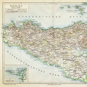
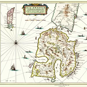
Antique Framed Print : Map of Sicily, by Willem Blaeu, from Regionum Italiae, engraving


![]()
Framed Photos from Universal Images Group (UIG)
Map of Sicily, by Willem Blaeu, from Regionum Italiae, engraving
Cartography, Italy, 17th century. Map of Sicily. From Regionum Italiae, by Willem Blaeu. Engraving
Universal Images Group (UIG) manages distribution for many leading specialist agencies worldwide
Media ID 9501733
© DEA PICTURE LIBRARY
17th Century Coat Of Arms Female Likeness Illustration Technique Island Mediterranean Sea Nautical Vessel Sailing Boat Sicily Transportation Western Script Willem Blaeu
14"x12" (36x31cm) Antique Frame
Bevelled wood effect frame, card mounted, 10x8 archival quality photo print. Overall outside dimensions 14x12 inches (36x31cm). Environmentally and ozone friendly, the Polycore® moulding has the look of real wood, is durable and light and easy to hang. Biodegradable and made with non-chlorinated gases (no toxic fumes) it is efficient; producing 100 tons of polystyrene can save 300 tons of trees! Prints are glazed with lightweight, shatterproof, optical clarity acrylic (providing the same general protection from the environment as glass). The back is stapled hardboard with a sawtooth hanger attached. Note: To minimise original artwork cropping, for optimum layout, and to ensure print is secure, the visible print may be marginally smaller
Bevelled Wood Effect Framed and Mounted Prints - Professionally Made and Ready to Hang
Estimated Image Size (if not cropped) is 24.4cm x 19.8cm (9.6" x 7.8")
Estimated Product Size is 36.3cm x 31.2cm (14.3" x 12.3")
These are individually made so all sizes are approximate
Artwork printed orientated as per the preview above, with landscape (horizontal) orientation to match the source image.
FEATURES IN THESE COLLECTIONS
> Arts
> Artists
> B
> Willem Blaeu
> Europe
> Italy
> Sicily
> Related Images
> Maps and Charts
> Italy
> Maps and Charts
> Related Images
> Universal Images Group (UIG)
> Art
> Painting, Sculpture & Prints
> Cartography
EDITORS COMMENTS
This print showcases a stunning map of Sicily, created by the talented cartographer Willem Blaeu in the 17th century. The intricate engraving captures every detail of this beautiful Italian island, offering a glimpse into its rich history and culture. The map is adorned with exquisite illustrations, including a coat of arms and a sailing boat navigating the Mediterranean Sea. Its horizontal layout allows viewers to explore Sicily from coast to coast, immersing themselves in its diverse landscapes and charming towns. Willem Blaeu's artistic prowess shines through in this engraved image, displaying his mastery of illustration techniques. The use of Western script adds an elegant touch to the map's overall aesthetic. Although devoid of people, this studio shot transports us back in time as we imagine ancient travelers using similar maps to navigate their way around Sicily. It serves as a reminder that even centuries ago, travel was an essential part of human existence. Whether you are an art enthusiast or simply fascinated by historical cartography, this print offers a unique opportunity to appreciate both the beauty and functionality of maps. Hang it on your wall or display it proudly on your desk – let it inspire wanderlust and ignite curiosity about Sicily's past and present.
MADE IN THE UK
Safe Shipping with 30 Day Money Back Guarantee
FREE PERSONALISATION*
We are proud to offer a range of customisation features including Personalised Captions, Color Filters and Picture Zoom Tools
SECURE PAYMENTS
We happily accept a wide range of payment options so you can pay for the things you need in the way that is most convenient for you
* Options may vary by product and licensing agreement. Zoomed Pictures can be adjusted in the Basket.