Antique Framed Print > Universal Images Group (UIG) > Art > Painting, Sculpture & Prints > Cartography
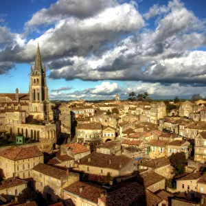
Antique Framed Print : Map of Rouen, Nimes and Bordeaux from Civitates Orbis Terrarum by Georg Braun, 1541-1622 and Franz Hogenberg, 1540-1590, engraving


![]()
Framed Photos from Universal Images Group (UIG)
Map of Rouen, Nimes and Bordeaux from Civitates Orbis Terrarum by Georg Braun, 1541-1622 and Franz Hogenberg, 1540-1590, engraving
Cartography, France, 16th century. Map of Rouen, Nimes and Bordeaux. From Civitates Orbis Terrarum by Georg Braun (1541-1622) and Franz Hogenberg (1540-1590), Cologne. Engraving
Universal Images Group (UIG) manages distribution for many leading specialist agencies worldwide
Media ID 9505253
© DEA / R. MERLO
16th Century Bordeaux Elevated View Horizon Over Land Manuscript Nimes River Rolling Landscape Rouen Townscape
14"x12" (36x31cm) Antique Frame
Bevelled wood effect frame, card mounted, 10x8 archival quality photo print. Overall outside dimensions 14x12 inches (36x31cm). Environmentally and ozone friendly, the Polycore® moulding has the look of real wood, is durable and light and easy to hang. Biodegradable and made with non-chlorinated gases (no toxic fumes) it is efficient; producing 100 tons of polystyrene can save 300 tons of trees! Prints are glazed with lightweight, shatterproof, optical clarity acrylic (providing the same general protection from the environment as glass). The back is stapled hardboard with a sawtooth hanger attached. Note: To minimise original artwork cropping, for optimum layout, and to ensure print is secure, the visible print may be marginally smaller
Bevelled Wood Effect Framed and Mounted Prints - Professionally Made and Ready to Hang
Estimated Image Size (if not cropped) is 24.4cm x 17.8cm (9.6" x 7")
Estimated Product Size is 36.3cm x 31.2cm (14.3" x 12.3")
These are individually made so all sizes are approximate
Artwork printed orientated as per the preview above, with landscape (horizontal) orientation to match the source image.
EDITORS COMMENTS
This print showcases a remarkable piece of cartography from the 16th century, specifically the Map of Rouen, Nimes, and Bordeaux. Created by Georg Braun (1541-1622) and Franz Hogenberg (1540-1590), this engraving is part of their renowned work called Civitates Orbis Terrarum. The intricate details and precision in this map offer a glimpse into the historical significance of these French towns during that era. The studio shot captures every stroke and line on the manuscript with utmost clarity. As we explore this horizontal landscape, we are transported back in time to witness the physical geography of Rouen, Nimes, and Bordeaux. The rolling landscape depicted here reveals an elevated view that beautifully illustrates the natural beauty surrounding these towns. Notably absent from this artwork are any human figures; instead, our attention is drawn to the meandering river that gracefully winds its way through these regions. This composition allows us to focus solely on appreciating the artistry behind this illustration while also contemplating France's rich history. With its impeccable craftsmanship and meticulous attention to detail, it is evident why this engraving has stood the test of time as a significant contribution to cartography. Whether you have an affinity for historical maps or simply appreciate fine artistry, this print serves as a stunning reminder of how geography intertwines with culture throughout centuries past.
MADE IN THE UK
Safe Shipping with 30 Day Money Back Guarantee
FREE PERSONALISATION*
We are proud to offer a range of customisation features including Personalised Captions, Color Filters and Picture Zoom Tools
SECURE PAYMENTS
We happily accept a wide range of payment options so you can pay for the things you need in the way that is most convenient for you
* Options may vary by product and licensing agreement. Zoomed Pictures can be adjusted in the Basket.