Antique Framed Print > Arts > Artists > H > Franz Hogenberg
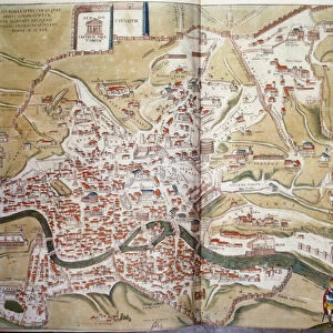
Antique Framed Print : Map of Perugia from Civitates Orbis Terrarum by Georg Braun, 1541-1622 and Franz Hogenberg, 1540-1590, engraving


![]()
Framed Photos from Universal Images Group (UIG)
Map of Perugia from Civitates Orbis Terrarum by Georg Braun, 1541-1622 and Franz Hogenberg, 1540-1590, engraving
Cartography, Italy, 16th century. Map of Perugia. From Civitates Orbis Terrarum by Georg Braun (1541-1622) and Franz Hogenberg (1540-1590), Cologne. Engraving
Universal Images Group (UIG) manages distribution for many leading specialist agencies worldwide
Media ID 9502421
© DEA / R. MERLO
16th Century Hill Latin Script Manuscript Perugia Townscape
14"x12" (36x31cm) Antique Frame
Bevelled wood effect frame, card mounted, 10x8 archival quality photo print. Overall outside dimensions 14x12 inches (36x31cm). Environmentally and ozone friendly, the Polycore® moulding has the look of real wood, is durable and light and easy to hang. Biodegradable and made with non-chlorinated gases (no toxic fumes) it is efficient; producing 100 tons of polystyrene can save 300 tons of trees! Prints are glazed with lightweight, shatterproof, optical clarity acrylic (providing the same general protection from the environment as glass). The back is stapled hardboard with a sawtooth hanger attached. Note: To minimise original artwork cropping, for optimum layout, and to ensure print is secure, the visible print may be marginally smaller
Bevelled Wood Effect Framed and Mounted Prints - Professionally Made and Ready to Hang
Estimated Image Size (if not cropped) is 24.4cm x 19.8cm (9.6" x 7.8")
Estimated Product Size is 36.3cm x 31.2cm (14.3" x 12.3")
These are individually made so all sizes are approximate
Artwork printed orientated as per the preview above, with landscape (horizontal) orientation to match the source image.
FEATURES IN THESE COLLECTIONS
> Arts
> Art Movements
> Landscapes
> Arts
> Artists
> H
> Franz Hogenberg
> Arts
> Landscape paintings
> Landscape art
> Europe
> Italy
> Umbria
> Perugia
> Maps and Charts
> Italy
> Maps and Charts
> Related Images
> Universal Images Group (UIG)
> Art
> Painting, Sculpture & Prints
> Cartography
EDITORS COMMENTS
This print showcases a remarkable piece of cartographic history - the Map of Perugia from Civitates Orbis Terrarum by Georg Braun and Franz Hogenberg. Created in the 16th century, this engraving provides an intricate depiction of Perugia, Italy's enchanting hilltop town. The studio shot captures every minute detail of this manuscript, revealing a townscape that transports us back in time. The landscape is beautifully rendered with precision and artistry, showcasing the physical geography of Perugia and its surrounding areas. As we delve into the map's intricacies, we are reminded of its historical significance. It serves as a testament to the skillful craftsmanship employed during this era. The Latin script adorning the map adds an air of authenticity and further emphasizes its importance as a valuable artifact. While devoid of people, this image allows us to immerse ourselves in both the beauty and historical context it represents. We can almost imagine strolling through Perugia's narrow streets or exploring its ancient landmarks. This print not only appeals to enthusiasts interested in cartography but also captivates those who appreciate illustration and painting as forms of art. It stands as a testament to human curiosity about our world throughout centuries past
MADE IN THE UK
Safe Shipping with 30 Day Money Back Guarantee
FREE PERSONALISATION*
We are proud to offer a range of customisation features including Personalised Captions, Color Filters and Picture Zoom Tools
SECURE PAYMENTS
We happily accept a wide range of payment options so you can pay for the things you need in the way that is most convenient for you
* Options may vary by product and licensing agreement. Zoomed Pictures can be adjusted in the Basket.