Antique Framed Print > Europe > Italy > Maps
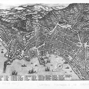
Antique Framed Print : Map of Italy, From Geographiae Opus Novissima by Martin Waldseemueller, Woodcut, 1513


![]()
Framed Photos from Universal Images Group (UIG)
Map of Italy, From Geographiae Opus Novissima by Martin Waldseemueller, Woodcut, 1513
Cartography, 16th century. Map of Italy. From Geographiae Opus Novissima by Martin Waldseemueller, 1513. Woodcut
Universal Images Group (UIG) manages distribution for many leading specialist agencies worldwide
Media ID 9572957
© DEA PICTURE LIBRARY
14"x12" (36x31cm) Antique Frame
Bevelled wood effect frame, card mounted, 10x8 archival quality photo print. Overall outside dimensions 14x12 inches (36x31cm). Environmentally and ozone friendly, the Polycore® moulding has the look of real wood, is durable and light and easy to hang. Biodegradable and made with non-chlorinated gases (no toxic fumes) it is efficient; producing 100 tons of polystyrene can save 300 tons of trees! Prints are glazed with lightweight, shatterproof, optical clarity acrylic (providing the same general protection from the environment as glass). The back is stapled hardboard with a sawtooth hanger attached. Note: To minimise original artwork cropping, for optimum layout, and to ensure print is secure, the visible print may be marginally smaller
Bevelled Wood Effect Framed and Mounted Prints - Professionally Made and Ready to Hang
Estimated Image Size (if not cropped) is 24.4cm x 18.6cm (9.6" x 7.3")
Estimated Product Size is 36.3cm x 31.2cm (14.3" x 12.3")
These are individually made so all sizes are approximate
Artwork printed orientated as per the preview above, with landscape (horizontal) orientation to match the source image.
FEATURES IN THESE COLLECTIONS
> Maps and Charts
> Italy
> Maps and Charts
> Related Images
> Universal Images Group (UIG)
> Art
> Painting, Sculpture & Prints
> Cartography
EDITORS COMMENTS
This print showcases a remarkable piece of cartographic history - the "Map of Italy" from Geographiae Opus Novissima by Martin Waldseemueller. Created in 1513, this woodcut map is an exquisite example of 16th-century craftsmanship and artistic skill. The map itself is a true testament to Waldseemueller's expertise as a cartographer. It beautifully depicts the intricate details of Italy's geography, with its distinctive boot-shaped peninsula and surrounding islands. The precision and accuracy displayed in this work are truly awe-inspiring, considering it was created centuries before modern mapping techniques were developed. As we delve into the historical significance of this piece, we gain insight into the world during that era. This map offers us a glimpse into how people perceived and understood their surroundings at that time. It serves as a reminder of the importance placed on exploration and discovery during the Renaissance period. The woodcut technique used to create this map adds an extra layer of charm to its overall aesthetic appeal. The fine lines etched onto wood bring out every minute detail with exceptional clarity, making it even more visually striking. This print allows us to appreciate not only the artistry behind Waldseemueller's creation but also provides us with an opportunity to connect with our past through one man's interpretation of Italy's landscape over five centuries ago.
MADE IN THE UK
Safe Shipping with 30 Day Money Back Guarantee
FREE PERSONALISATION*
We are proud to offer a range of customisation features including Personalised Captions, Color Filters and Picture Zoom Tools
SECURE PAYMENTS
We happily accept a wide range of payment options so you can pay for the things you need in the way that is most convenient for you
* Options may vary by product and licensing agreement. Zoomed Pictures can be adjusted in the Basket.