Antique Framed Print > Arts > Artists > O > Abraham Ortelius
Antique Framed Print : 16th century map of the British Isles


![]()
Framed Photos from Science Photo Library
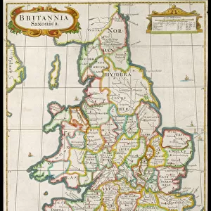
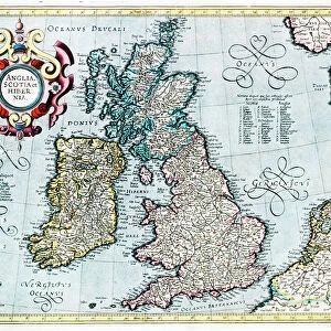
16th century map of the British Isles
Map of the British Isles, in the 1570 edition of Ortelius Atlas (Theatrum Orbis Terrarum). Abraham Ortelius (1527-1598) was a Flemish mapmaker who is considered to have produced the first true atlas (collection of uniform maps in one book). Ortelius worked in Antwerp, the Netherlands. This map is titled: Angliae, Scotiae et Hiberniae (England, Scotland and Ireland). The text at upper right is in Latin and mentions Saxons and Albion (another term for Britain). A royal coat of arms is seen at lower left
Science Photo Library features Science and Medical images including photos and illustrations
Media ID 6348369
© LIBRARY OF CONGRESS, GEOGRAPHY AND MAP DIVISION/SCIENCE PHOTO LIBRARY
1500s 1570 16th Century Abraham Ortelius Ancient British Isles Cartography Coat Of Arms Country Diagram Dutch Flemish Illustrated Inaccurate Incomplete Ireland Irish Latin Nation Renaissance Scot Land Scottish Theatrum Orbis Terrarum Wales Welsh Library Of Congress
14"x12" (36x31cm) Antique Frame
Bevelled wood effect frame, card mounted, 10x8 archival quality photo print. Overall outside dimensions 14x12 inches (36x31cm). Environmentally and ozone friendly, the Polycore® moulding has the look of real wood, is durable and light and easy to hang. Biodegradable and made with non-chlorinated gases (no toxic fumes) it is efficient; producing 100 tons of polystyrene can save 300 tons of trees! Prints are glazed with lightweight, shatterproof, optical clarity acrylic (providing the same general protection from the environment as glass). The back is stapled hardboard with a sawtooth hanger attached. Note: To minimise original artwork cropping, for optimum layout, and to ensure print is secure, the visible print may be marginally smaller
Bevelled Wood Effect Framed and Mounted Prints - Professionally Made and Ready to Hang
Estimated Image Size (if not cropped) is 18.5cm x 24.4cm (7.3" x 9.6")
Estimated Product Size is 31.2cm x 36.3cm (12.3" x 14.3")
These are individually made so all sizes are approximate
Artwork printed orientated as per the preview above, with portrait (vertical) orientation to match the source image.
FEATURES IN THESE COLLECTIONS
> Arts
> Art Movements
> Renaissance Art
> Arts
> Artists
> O
> Abraham Ortelius
> Europe
> France
> Canton
> Landes
> Europe
> Netherlands
> Maps
> Europe
> Netherlands
> Posters
> Europe
> Netherlands
> Related Images
> Europe
> Republic of Ireland
> Maps
> Europe
> United Kingdom
> England
> Maps
> Europe
> United Kingdom
> Maps
> Europe
> United Kingdom
> Related Images
> Maps and Charts
> Abraham Ortelius
EDITORS COMMENTS
This print showcases a remarkable piece of history - a 16th-century map of the British Isles. Crafted by Abraham Ortelius, a renowned Flemish mapmaker and considered the pioneer of atlases, this particular map is part of his esteemed work, the 1570 edition of Ortelius Atlas (Theatrum Orbis Terrarum). Titled "Angliae, Scotiae et Hiberniae" which translates to England, Scotland, and Ireland in Latin, this intricate illustration provides a glimpse into the geographical landscape during that era. The text inscribed in Latin at the upper right corner mentions Saxons and Albion - an alternate term for Britain. One cannot help but be captivated by the royal coat of arms prominently displayed at lower left on this ancient cartographic masterpiece. It serves as a testament to the historical significance attached to these lands. While it's important to note that this 16th-century map may not be entirely accurate or complete according to modern standards, its artistic value and contribution to our understanding of British history are undeniable. This beautifully illustrated work offers us insights into how people perceived their world centuries ago. Preserved within the Library of Congress archives, this Dutch-Scottish collaboration between Ortelius and Scottish engraver Michael Fleming stands as an enduring symbol of cultural exchange during Europe's Renaissance period. A true treasure for enthusiasts interested in geography, history, artistry or simply those who appreciate glimpses into our past.
MADE IN THE UK
Safe Shipping with 30 Day Money Back Guarantee
FREE PERSONALISATION*
We are proud to offer a range of customisation features including Personalised Captions, Color Filters and Picture Zoom Tools
SECURE PAYMENTS
We happily accept a wide range of payment options so you can pay for the things you need in the way that is most convenient for you
* Options may vary by product and licensing agreement. Zoomed Pictures can be adjusted in the Basket.