Antique Framed Print > Europe > Russia > Maps
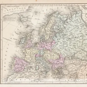
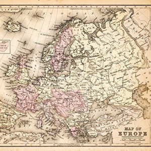
Antique Framed Print : Map of Europe, 1870s


![]()
Framed Photos from North Wind
Map of Europe, 1870s
Map of Europe in the 1870s.
Color lithograph reproduction of a 19th-century illustration
North Wind Picture Archives brings history to life with stock images and hand-colored illustrations
Media ID 5882054
© North Wind Picture Archives
14"x12" (36x31cm) Antique Frame
Bevelled wood effect frame, card mounted, 10x8 archival quality photo print. Overall outside dimensions 14x12 inches (36x31cm). Environmentally and ozone friendly, the Polycore® moulding has the look of real wood, is durable and light and easy to hang. Biodegradable and made with non-chlorinated gases (no toxic fumes) it is efficient; producing 100 tons of polystyrene can save 300 tons of trees! Prints are glazed with lightweight, shatterproof, optical clarity acrylic (providing the same general protection from the environment as glass). The back is stapled hardboard with a sawtooth hanger attached. Note: To minimise original artwork cropping, for optimum layout, and to ensure print is secure, the visible print may be marginally smaller
Bevelled Wood Effect Framed and Mounted Prints - Professionally Made and Ready to Hang
Estimated Image Size (if not cropped) is 24.4cm x 18.2cm (9.6" x 7.2")
Estimated Product Size is 36.3cm x 31.2cm (14.3" x 12.3")
These are individually made so all sizes are approximate
Artwork printed orientated as per the preview above, with landscape (horizontal) orientation to match the source image.
FEATURES IN THESE COLLECTIONS
> Europe
> Russia
> Related Images
> Maps and Charts
> Related Images
> North Wind Picture Archives
> Maps
EDITORS COMMENTS
This print showcases a remarkable piece of history - the Map of Europe in the 1870s. With its vibrant colors and intricate details, this color lithograph reproduction transports us back to a bygone era. The map itself is a testament to the rich heritage and traditional roots that define Europe. As we gaze upon this vintage illustration, our eyes are immediately drawn to Russia, which looms large on the map. Its vast expanse stretches across much of Eastern Europe, reminding us of its significant influence during this period. Surrounding countries such as Germany, France, Austria-Hungary, and Italy are also prominently featured with their distinct borders and territories. Every inch of this historic artwork tells a story about the political landscape and shifting alliances that characterized 19th-century Europe. It serves as an invaluable resource for historians and enthusiasts alike who seek to understand how nations evolved over time. The artistry behind this illustration is truly exceptional; it captures both accuracy and beauty simultaneously. The delicate lines and careful shading bring each country's shape to life while maintaining an overall sense of harmony within the composition. Whether you have an affinity for cartography or simply appreciate fine art from the 1800s, this Map of Europe from North Wind Picture Archives will undoubtedly captivate your imagination. Let it transport you back in time as you explore the intricacies of European history through this stunning visual representation.
MADE IN THE UK
Safe Shipping with 30 Day Money Back Guarantee
FREE PERSONALISATION*
We are proud to offer a range of customisation features including Personalised Captions, Color Filters and Picture Zoom Tools
SECURE PAYMENTS
We happily accept a wide range of payment options so you can pay for the things you need in the way that is most convenient for you
* Options may vary by product and licensing agreement. Zoomed Pictures can be adjusted in the Basket.