Antique Framed Print > Africa > Egypt > Cairo
Antique Framed Print : Orient Express - Map of the Overland Route to Cairo


![]()
Framed Photos from Mary Evans Picture Library
Orient Express - Map of the Overland Route to Cairo
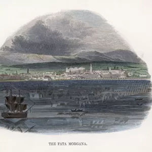
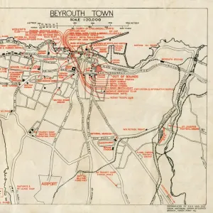
Eliminating the Mediterranean Voyage in the journey to Egypt - The Overland Route to Cairo. The Map of the overland route shows the train line through Western Europe through to Turkey and then through North Syria, Lebanon, Palestine and Egypt. The map shows part of the railway between Tripoli (Lebanon) and Haifa (then Palestine) still uncompleted. Date: April 19 1928
Mary Evans Picture Library makes available wonderful images created for people to enjoy over the centuries
Media ID 14371002
© Illustrated London News Ltd/Mary Evans
Express Mar16 Minor Network Orient Overland Palestine Plan Route Syria Taurus Track
21"x16" (54x41cm) Antique Frame
Bevelled wood effect frame, card mounted, 15x10 archival quality photo print. Overall outside dimensions 21x16 inches (54x41cm). Environmentally and ozone friendly, Polycore® moulding has the look of real wood, is durable and light and easy to hang. Biodegradable and made with non-chlorinated gases (no toxic fumes) it is efficient; producing 100 tons of polystyrene can save 300 tons of trees! Prints are glazed with lightweight, shatterproof, optical clarity acrylic (providing the same general protection from the environment as glass). The back is stapled hardboard with a sawtooth hanger attached. Note: To minimise original artwork cropping, for optimum layout, and to ensure print is secure, the visible print may be marginally smaller
Bevelled Wood Effect Framed and Mounted Prints - Professionally Made and Ready to Hang
Estimated Image Size (if not cropped) is 37.1cm x 17.5cm (14.6" x 6.9")
Estimated Product Size is 54cm x 41.4cm (21.3" x 16.3")
These are individually made so all sizes are approximate
Artwork printed orientated as per the preview above, with landscape (horizontal) orientation to match the source image.
FEATURES IN THESE COLLECTIONS
> Africa
> Egypt
> Related Images
> Animals
> Mammals
> Bovidae
> Taurus
> Animals
> Mammals
> Muridae
> Western Mediterranean Mouse
> Animals
> Mammals
> Muridae
> Western Mouse
> Arts
> Artists
> S
> Syrian Syrian
> Asia
> Lebanon
> Related Images
EDITORS COMMENTS
This map print depicts the Overland Route to Cairo, an alternative to the traditional Mediterranean voyage for travelers heading to Egypt. Dated April 19, 1928, the map illustrates the Orient Express's railway line traversing Western Europe, Turkey, North Syria, Lebanon, Palestine, and Egypt. The meticulously planned network eliminates the need for a Mediterranean voyage, offering a more direct and intriguing journey through Asia Minor. The map reveals the railway's progression from Europe through the Balkans, Bulgaria, and Romania, continuing on to the Black Sea and the Bosphorus Strait. The route then passes through Anatolia in Turkey, followed by the Middle Eastern countries of North Syria, Lebanon, and Palestine. The map also highlights the part of the railway line between Tripoli, Lebanon, and Haifa, Palestine, which was still under construction at the time. The Overland Route to Cairo represented a significant achievement in the development of international railway networks during the early 20th century. It offered travelers an opportunity to explore diverse cultures and landscapes, bridging the gap between Europe and the Middle East. This map serves as a testament to the ingenuity and ambition of the railway engineers and planners who made this remarkable journey possible.
MADE IN THE UK
Safe Shipping with 30 Day Money Back Guarantee
FREE PERSONALISATION*
We are proud to offer a range of customisation features including Personalised Captions, Color Filters and Picture Zoom Tools
SECURE PAYMENTS
We happily accept a wide range of payment options so you can pay for the things you need in the way that is most convenient for you
* Options may vary by product and licensing agreement. Zoomed Pictures can be adjusted in the Basket.