Antique Framed Print > Africa > South Africa > Maps
Antique Framed Print : Map /s Africa / Boer C1898


![]()
Framed Photos from Mary Evans Picture Library
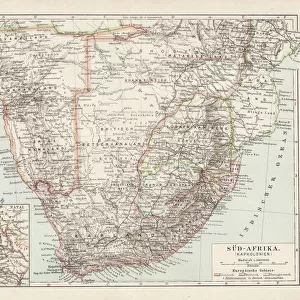
Map /s Africa / Boer C1898
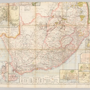
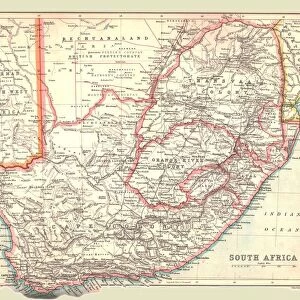
SOUTH AFRICA on the eve of the Boer War
Mary Evans Picture Library makes available wonderful images created for people to enjoy over the centuries
Media ID 571757
© Mary Evans Picture Library 2015 - https://copyrighthub.org/s0/hub1/creation/maryevans/MaryEvansPictureID/10004464
14"x12" (36x31cm) Antique Frame
Bevelled wood effect frame, card mounted, 10x8 archival quality photo print. Overall outside dimensions 14x12 inches (36x31cm). Environmentally and ozone friendly, the Polycore® moulding has the look of real wood, is durable and light and easy to hang. Biodegradable and made with non-chlorinated gases (no toxic fumes) it is efficient; producing 100 tons of polystyrene can save 300 tons of trees! Prints are glazed with lightweight, shatterproof, optical clarity acrylic (providing the same general protection from the environment as glass). The back is stapled hardboard with a sawtooth hanger attached. Note: To minimise original artwork cropping, for optimum layout, and to ensure print is secure, the visible print may be marginally smaller
Bevelled Wood Effect Framed and Mounted Prints - Professionally Made and Ready to Hang
Estimated Image Size (if not cropped) is 24.4cm x 17.1cm (9.6" x 6.7")
Estimated Product Size is 36.3cm x 31.2cm (14.3" x 12.3")
These are individually made so all sizes are approximate
Artwork printed orientated as per the preview above, with landscape (horizontal) orientation to match the source image.
FEATURES IN THESE COLLECTIONS
> Africa
> Related Images
> Africa
> South Africa
> Maps
> Africa
> South Africa
> Related Images
> Maps and Charts
> Early Maps
> Maps and Charts
> Related Images
EDITORS COMMENTS
This historical map print, titled "Map of South Africa, circa 1898: On the Eve of the Boer War," offers a fascinating glimpse into the geopolitical landscape of South Africa just prior to the outbreak of the Second Boer War. The map, from Mary Evans Picture Library, depicts the region with remarkable detail, highlighting the various territories controlled by the British, the Boers, and other European powers. The Boer Wars, a series of conflicts between the British and the Dutch-speaking Boer farmers, began in 1899 and lasted until 1902. This map, produced in 1898, provides a snapshot of the political situation in the region at the height of tensions between the British and the Boers. The map shows the British colonies of the Cape Colony, Natal, and the Transvaal and Orange Free State, which were governed by the Boers. The map also illustrates the various borders and territories claimed by European powers, including Germany and Portugal. The map's intricate detail includes the location of major cities, rivers, mountains, and roads, making it an invaluable resource for scholars and historians studying the period. The map also includes annotations indicating the location of important historical sites, such as the Battle of Majuba Hill, which took place in 1881 and is considered the beginning of the First Boer War. The "Map of South Africa, circa 1898: On the Eve of the Boer War" is a testament to the rich history of South Africa and the complex political situation that led to the conflicts between the British and the Boers. It offers a unique perspective on a pivotal moment in history and is a must-have for any collection focused on African history or the history of colonialism.
MADE IN THE UK
Safe Shipping with 30 Day Money Back Guarantee
FREE PERSONALISATION*
We are proud to offer a range of customisation features including Personalised Captions, Color Filters and Picture Zoom Tools
SECURE PAYMENTS
We happily accept a wide range of payment options so you can pay for the things you need in the way that is most convenient for you
* Options may vary by product and licensing agreement. Zoomed Pictures can be adjusted in the Basket.