Antique Framed Print > Europe > United Kingdom > Wales > Maps
Antique Framed Print : Map / England & Wales 1857


![]()
Framed Photos from Mary Evans Picture Library
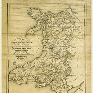
Map / England & Wales 1857
Map of England and Wales showing roads and rivers Date: circa 1857
Mary Evans Picture Library makes available wonderful images created for people to enjoy over the centuries
Media ID 14291473
© Mary Evans Picture Library
14"x12" (36x31cm) Antique Frame
Bevelled wood effect frame, card mounted, 10x8 archival quality photo print. Overall outside dimensions 14x12 inches (36x31cm). Environmentally and ozone friendly, the Polycore® moulding has the look of real wood, is durable and light and easy to hang. Biodegradable and made with non-chlorinated gases (no toxic fumes) it is efficient; producing 100 tons of polystyrene can save 300 tons of trees! Prints are glazed with lightweight, shatterproof, optical clarity acrylic (providing the same general protection from the environment as glass). The back is stapled hardboard with a sawtooth hanger attached. Note: To minimise original artwork cropping, for optimum layout, and to ensure print is secure, the visible print may be marginally smaller
Bevelled Wood Effect Framed and Mounted Prints - Professionally Made and Ready to Hang
Estimated Image Size (if not cropped) is 19.1cm x 24.4cm (7.5" x 9.6")
Estimated Product Size is 31.2cm x 36.3cm (12.3" x 14.3")
These are individually made so all sizes are approximate
Artwork printed orientated as per the preview above, with portrait (vertical) orientation to match the source image.
FEATURES IN THESE COLLECTIONS
> Arts
> Landscape paintings
> Waterfall and river artworks
> River artworks
> Europe
> United Kingdom
> England
> Maps
> Europe
> United Kingdom
> England
> Posters
> Europe
> United Kingdom
> England
> Related Images
> Europe
> United Kingdom
> England
> Rivers
> Europe
> United Kingdom
> Wales
> Maps
> Europe
> United Kingdom
> Wales
> Posters
> Europe
> United Kingdom
> Wales
> Related Images
> Europe
> United Kingdom
> Wales
> Rivers
> Maps and Charts
> Related Images
EDITORS COMMENTS
1. Title: "A Journey Through Time: Exploring England & Wales in 1857 as Revealed in this Detailed Map" This antique map print, dating back to circa 1857, offers a fascinating glimpse into the geography of England and Wales during the Victorian era. The intricately detailed map showcases the roads and rivers that crisscrossed the two countries, providing valuable insight into the transportation networks of the time. The map's rich history is evident in its meticulous depiction of the British Isles, with the intricate winding roads and meandering rivers revealing the topography of the land. The map's vintage charm transports us back to an era when travel was an adventure, and the exploration of new territories was a source of wonder and discovery. England and Wales in 1857 were undergoing significant changes, with the Industrial Revolution transforming the landscape and the population continuing to grow. This map serves as a testament to the progress that had been made, as well as a reminder of the challenges and complexities of navigating the country during this period. The map's antique aesthetic, with its intricate border design and use of muted colors, adds to its allure, making it a beautiful addition to any home or office. Whether used as a conversation starter, a decorative piece, or a research tool, this map is sure to captivate anyone with an interest in history, geography, or the Victorian era. This map is not only a valuable historical document but also a reminder of the rich cultural heritage that makes up the fabric of England and Wales. It invites us to explore the past and to appreciate the evolution of our world over time.
MADE IN THE UK
Safe Shipping with 30 Day Money Back Guarantee
FREE PERSONALISATION*
We are proud to offer a range of customisation features including Personalised Captions, Color Filters and Picture Zoom Tools
SECURE PAYMENTS
We happily accept a wide range of payment options so you can pay for the things you need in the way that is most convenient for you
* Options may vary by product and licensing agreement. Zoomed Pictures can be adjusted in the Basket.