Antique Framed Print > Maps and Charts > Early Maps
Antique Framed Print : Map / Channel Islands 18C


![]()
Framed Photos from Mary Evans Picture Library
Map / Channel Islands 18C
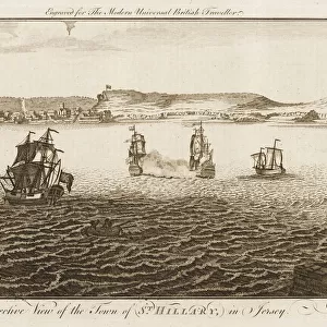
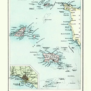
Map of Jersey, Guernsey, Alderney, Sark and the Scilly Isles
Mary Evans Picture Library makes available wonderful images created for people to enjoy over the centuries
Media ID 607569
© Mary Evans Picture Library 2015 - https://copyrighthub.org/s0/hub1/creation/maryevans/MaryEvansPictureID/10059488
Alderney Channel Guernsey Isles Jersey Maps S Ark Scilly
14"x12" (36x31cm) Antique Frame
Bevelled wood effect frame, card mounted, 10x8 archival quality photo print. Overall outside dimensions 14x12 inches (36x31cm). Environmentally and ozone friendly, the Polycore® moulding has the look of real wood, is durable and light and easy to hang. Biodegradable and made with non-chlorinated gases (no toxic fumes) it is efficient; producing 100 tons of polystyrene can save 300 tons of trees! Prints are glazed with lightweight, shatterproof, optical clarity acrylic (providing the same general protection from the environment as glass). The back is stapled hardboard with a sawtooth hanger attached. Note: To minimise original artwork cropping, for optimum layout, and to ensure print is secure, the visible print may be marginally smaller
Bevelled Wood Effect Framed and Mounted Prints - Professionally Made and Ready to Hang
Estimated Image Size (if not cropped) is 24.4cm x 19.2cm (9.6" x 7.6")
Estimated Product Size is 36.3cm x 31.2cm (14.3" x 12.3")
These are individually made so all sizes are approximate
Artwork printed orientated as per the preview above, with landscape (horizontal) orientation to match the source image.
FEATURES IN THESE COLLECTIONS
> Maps and Charts
> Early Maps
> Maps and Charts
> Related Images
EDITORS COMMENTS
This stunning historical print showcases a detailed map of the Channel Islands in the 18th century, including Jersey, Guernsey, Alderney, Sark and the Scilly Isles. The intricate details and vibrant colors bring to life the rich history and significance of these islands in centuries past.
Each island is clearly labeled on the map, allowing viewers to imagine what life was like in this region during this time period. From bustling ports to quaint villages, this map provides a glimpse into the diverse landscapes and communities that existed on these islands hundreds of years ago.
The meticulous craftsmanship of this map is evident in every line and symbol, reflecting the expertise and dedication of cartographers from centuries past. It serves as a reminder of how maps have been essential tools for exploration, navigation, and understanding our world throughout history.
Whether you have a personal connection to these islands or simply appreciate historical artifacts, this print is sure to captivate your imagination and spark curiosity about the stories hidden within its borders. Display it proudly in your home or office as a conversation piece that will transport you back in time to an era filled with discovery and adventure.
MADE IN THE UK
Safe Shipping with 30 Day Money Back Guarantee
FREE PERSONALISATION*
We are proud to offer a range of customisation features including Personalised Captions, Color Filters and Picture Zoom Tools
SECURE PAYMENTS
We happily accept a wide range of payment options so you can pay for the things you need in the way that is most convenient for you
* Options may vary by product and licensing agreement. Zoomed Pictures can be adjusted in the Basket.