Antique Framed Print > Europe > United Kingdom > England > Manchester > Worsley
Antique Framed Print : Bridgewater Canal Map


![]()
Framed Photos from Mary Evans Picture Library
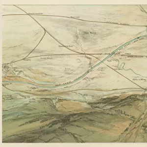
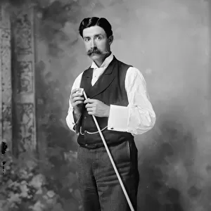
Bridgewater Canal Map
Map showing the route of the proposed canal from Worsley to Manchester and thence to the Mersey, to be built by engineer James Brindley for the duke of Bridgewater
Mary Evans Picture Library makes available wonderful images created for people to enjoy over the centuries
Media ID 4364878
© Mary Evans Picture Library 2015 - https://copyrighthub.org/s0/hub1/creation/maryevans/MaryEvansPictureID/10120431
1766 Bridgewater Brindley Canal Canals Engineer Invention Manchester Mersey Proposed Route Technology Worsley
21"x16" (54x41cm) Antique Frame
Bevelled wood effect frame, card mounted, 15x10 archival quality photo print. Overall outside dimensions 21x16 inches (54x41cm). Environmentally and ozone friendly, Polycore® moulding has the look of real wood, is durable and light and easy to hang. Biodegradable and made with non-chlorinated gases (no toxic fumes) it is efficient; producing 100 tons of polystyrene can save 300 tons of trees! Prints are glazed with lightweight, shatterproof, optical clarity acrylic (providing the same general protection from the environment as glass). The back is stapled hardboard with a sawtooth hanger attached. Note: To minimise original artwork cropping, for optimum layout, and to ensure print is secure, the visible print may be marginally smaller
Bevelled Wood Effect Framed and Mounted Prints - Professionally Made and Ready to Hang
Estimated Image Size (if not cropped) is 37.1cm x 20.5cm (14.6" x 8.1")
Estimated Product Size is 54cm x 41.4cm (21.3" x 16.3")
These are individually made so all sizes are approximate
Artwork printed orientated as per the preview above, with landscape (horizontal) orientation to match the source image.
FEATURES IN THESE COLLECTIONS
> Europe
> United Kingdom
> England
> Manchester
> Manchester
> Europe
> United Kingdom
> England
> Manchester
> Worsley
> Maps and Charts
> Early Maps
> Maps and Charts
> Related Images
EDITORS COMMENTS
This print showcases a historical map of the Bridgewater Canal, a groundbreaking engineering feat that forever changed the landscape of Manchester, Britain. The map illustrates the proposed route of the canal from Worsley to Manchester and onwards to the Mersey, highlighting the visionary work of engineer James Brindley in bringing this ambitious project to life for the Duke of Bridgewater in 1766.
As you gaze upon this piece of history, you can't help but marvel at the intricate details and precision that went into planning such a monumental transportation system. The map serves as a testament to human ingenuity and innovation, showcasing how technology and industry intersected in creating new pathways for economic growth and development.
Through this visual representation, we are transported back in time to an era where canals were not just waterways but lifelines connecting communities and fostering trade. The legacy of James Brindley lives on through his pioneering work on the Bridgewater Canal, leaving behind a lasting impact on British transport history.
Whether you're a history buff or simply appreciate fine craftsmanship, this print is sure to captivate your imagination and inspire awe for those who dared to dream big and push boundaries in pursuit of progress.
MADE IN THE UK
Safe Shipping with 30 Day Money Back Guarantee
FREE PERSONALISATION*
We are proud to offer a range of customisation features including Personalised Captions, Color Filters and Picture Zoom Tools
SECURE PAYMENTS
We happily accept a wide range of payment options so you can pay for the things you need in the way that is most convenient for you
* Options may vary by product and licensing agreement. Zoomed Pictures can be adjusted in the Basket.