Antique Framed Print > Arts > Artists > T > John Tallis
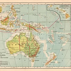
Antique Framed Print : Polynesia, or Islands in the Pacific Ocean 1851


![]()
Framed Photos from MapSeeker
Polynesia, or Islands in the Pacific Ocean 1851
A fine facimile artworked from an antique original map of Polynesia, or Islands in the Pacific Ocean, issued as part of the 1851 edition of John Tallis and Companys " The Illustrated Atlas and Modern History of the World"
Welcome to the Mapseeker Image library and enter an historic gateway to one of the largest on-line collections of Historic Maps, Nostalgic Views, Vista's and Panorama's from a World gone by.
Media ID 20347497
© Mapseeker Publishing Ltd
John Tallis John Tallis Map Tallis Map Polynesia
21"x16" (54x41cm) Antique Frame
Bevelled wood effect frame, card mounted, 15x10 archival quality photo print. Overall outside dimensions 21x16 inches (54x41cm). Environmentally and ozone friendly, Polycore® moulding has the look of real wood, is durable and light and easy to hang. Biodegradable and made with non-chlorinated gases (no toxic fumes) it is efficient; producing 100 tons of polystyrene can save 300 tons of trees! Prints are glazed with lightweight, shatterproof, optical clarity acrylic (providing the same general protection from the environment as glass). The back is stapled hardboard with a sawtooth hanger attached. Note: To minimise original artwork cropping, for optimum layout, and to ensure print is secure, the visible print may be marginally smaller
Bevelled Wood Effect Framed and Mounted Prints - Professionally Made and Ready to Hang
Estimated Image Size (if not cropped) is 37.1cm x 24.7cm (14.6" x 9.7")
Estimated Product Size is 54cm x 41.4cm (21.3" x 16.3")
These are individually made so all sizes are approximate
Artwork printed orientated as per the preview above, with landscape (horizontal) orientation to match the source image.
FEATURES IN THESE COLLECTIONS
> Arts
> Artists
> T
> John Tallis
> Maps and Charts
> Related Images
> Maps and Charts
> World
> MapSeeker
> Maps of Africa and Oceana
> Old Maps of New Zealand, Tasmania And
EDITORS COMMENTS
This print showcases a remarkable piece of cartographic history - an antique original map of Polynesia, or Islands in the Pacific Ocean. Crafted with utmost precision and attention to detail, this fine facsimile artwork is a testament to the expertise and artistry of John Tallis and Company. Dating back to 1851, this exquisite map was originally featured in "The Illustrated Atlas and Modern History of the World" a renowned publication that provided readers with comprehensive geographical knowledge. The map offers a fascinating glimpse into Polynesia's geography during that era, highlighting its numerous islands scattered across the vast Pacific Ocean. With its intricate illustrations and delicate color palette, this old map of Polynesia transports us back in time, evoking a sense of adventure and exploration. Each island is meticulously labeled, allowing viewers to immerse themselves in the rich tapestry of cultures that thrive within these tropical paradises. John Tallis' artistic prowess shines through every stroke on this masterpiece. His collaboration with John Rapkin has resulted in an enduring work that continues to captivate enthusiasts today. Whether you are an avid collector or simply appreciate historical artifacts, this stunning print will undoubtedly add depth and character to any space it graces. Embrace the allure of yesteryears as you admire this extraordinary depiction of Polynesia's enchanting islands - a true treasure for those who seek both beauty and knowledge from their surroundings.
MADE IN THE UK
Safe Shipping with 30 Day Money Back Guarantee
FREE PERSONALISATION*
We are proud to offer a range of customisation features including Personalised Captions, Color Filters and Picture Zoom Tools
SECURE PAYMENTS
We happily accept a wide range of payment options so you can pay for the things you need in the way that is most convenient for you
* Options may vary by product and licensing agreement. Zoomed Pictures can be adjusted in the Basket.