Antique Framed Print > Africa > Egypt > Maps
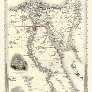
Antique Framed Print : Special War Map of Lower Egypt


![]()
Framed Photos from MapSeeker
Special War Map of Lower Egypt
BAT01002
Welcome to the Mapseeker Image library and enter an historic gateway to one of the largest on-line collections of Historic Maps, Nostalgic Views, Vista's and Panorama's from a World gone by.
Media ID 20347007
21"x16" (54x41cm) Antique Frame
Bevelled wood effect frame, card mounted, 15x10 archival quality photo print. Overall outside dimensions 21x16 inches (54x41cm). Environmentally and ozone friendly, Polycore® moulding has the look of real wood, is durable and light and easy to hang. Biodegradable and made with non-chlorinated gases (no toxic fumes) it is efficient; producing 100 tons of polystyrene can save 300 tons of trees! Prints are glazed with lightweight, shatterproof, optical clarity acrylic (providing the same general protection from the environment as glass). The back is stapled hardboard with a sawtooth hanger attached. Note: To minimise original artwork cropping, for optimum layout, and to ensure print is secure, the visible print may be marginally smaller
Bevelled Wood Effect Framed and Mounted Prints - Professionally Made and Ready to Hang
Estimated Image Size (if not cropped) is 37.1cm x 24.7cm (14.6" x 9.7")
Estimated Product Size is 54cm x 41.4cm (21.3" x 16.3")
These are individually made so all sizes are approximate
Artwork printed orientated as per the preview above, with landscape (horizontal) orientation to match the source image.
FEATURES IN THESE COLLECTIONS
> Africa
> Egypt
> Related Images
> Maps and Charts
> Related Images
> MapSeeker
> British History Related and Military
> 16th to 19th Century PORTFOLIO
EDITORS COMMENTS
This print showcases the "Special War Map of Lower Egypt (BAT01002)" from MapSeeker, offering a unique glimpse into the intricate details of this historical map. With its rich colors and meticulous cartographic precision, this piece transports us back in time to a crucial era of conflict and strategic maneuvering. The map itself is an invaluable resource for understanding the complex dynamics that shaped Lower Egypt during times of war. Every contour line, symbol, and label tells a story about military movements, fortifications, and key landmarks that played significant roles in battles fought on Egyptian soil. It serves as a testament to the importance placed on geography and intelligence gathering during wartime. As we explore this remarkable work of art, our eyes are drawn to the Nile River winding its way through fertile lands dotted with cities and towns. The detailed depiction of topography allows us to envision how these natural features influenced military strategies employed by ancient civilizations. Beyond its historical significance, this print also stands as a testament to human curiosity and fascination with maps throughout history. It reminds us that maps not only serve practical purposes but also hold artistic value as they capture both objective information and subjective interpretations. Whether you are an avid historian or simply appreciate fine craftsmanship, this print offers an opportunity to delve into the depths of Lower Egypt's past while marveling at the beauty inherent in cartography.
MADE IN THE UK
Safe Shipping with 30 Day Money Back Guarantee
FREE PERSONALISATION*
We are proud to offer a range of customisation features including Personalised Captions, Color Filters and Picture Zoom Tools
SECURE PAYMENTS
We happily accept a wide range of payment options so you can pay for the things you need in the way that is most convenient for you
* Options may vary by product and licensing agreement. Zoomed Pictures can be adjusted in the Basket.