Antique Framed Print > Africa > Namibia > Maps
Antique Framed Print : Map of Central Africa, 1902. Creator: Unknown


![]()
Framed Photos from Heritage Images
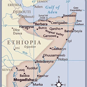
Map of Central Africa, 1902. Creator: Unknown
Map of Central Africa, 1902. Showing colonial possessions including Italian Somaliland, Portuguese East Africa, German East Africa, British Central Africa and French Congo From The Century Atlas of the World. [John Walker & Co, Ltd. London, 1902]
Heritage Images features heritage image collections
Media ID 15512666
© The Print Collector / Heritage-Images
Central Africa Edinburgh Geographical Institute German East Africa Imperialism Namibia Portugal Portuguese Somalia Somaliland
14"x12" (36x31cm) Antique Frame
Bevelled wood effect frame, card mounted, 10x8 archival quality photo print. Overall outside dimensions 14x12 inches (36x31cm). Environmentally and ozone friendly, the Polycore® moulding has the look of real wood, is durable and light and easy to hang. Biodegradable and made with non-chlorinated gases (no toxic fumes) it is efficient; producing 100 tons of polystyrene can save 300 tons of trees! Prints are glazed with lightweight, shatterproof, optical clarity acrylic (providing the same general protection from the environment as glass). The back is stapled hardboard with a sawtooth hanger attached. Note: To minimise original artwork cropping, for optimum layout, and to ensure print is secure, the visible print may be marginally smaller
Bevelled Wood Effect Framed and Mounted Prints - Professionally Made and Ready to Hang
Estimated Image Size (if not cropped) is 24.4cm x 18cm (9.6" x 7.1")
Estimated Product Size is 36.3cm x 31.2cm (14.3" x 12.3")
These are individually made so all sizes are approximate
Artwork printed orientated as per the preview above, with landscape (horizontal) orientation to match the source image.
FEATURES IN THESE COLLECTIONS
> Africa
> Namibia
> Related Images
> Africa
> Somalia
> Related Images
> Animals
> Mammals
> Cats (Domestic)
> Somali
EDITORS COMMENTS
This print showcases a Map of Central Africa from the year 1902, an era marked by intense colonialism and imperialistic pursuits. The creator of this map remains unknown, but its historical significance cannot be understated. With vibrant colors and intricate details, it provides a visual representation of the colonial possessions held by various European powers in Central Africa during that time. The map highlights notable territories such as Italian Somaliland, Portuguese East Africa, German East Africa, British Central Africa, and French Congo. Each country's presence is depicted with precision and accuracy, offering insights into the extent of their influence on the continent. This snapshot from The Century Atlas of the World published by John Walker & Co in London transports us back to an age when nations vied for control over vast expanses of land. As we examine this artifact closely, we are reminded of the complex dynamics at play during this period - imperialism shaping destinies and borders being redrawn. It serves as a reminder that history is not just about dates and events; it also encompasses human stories and struggles for power. Preserved by The Print Collector in collaboration with Heritage Images, this photograph allows us to appreciate both its aesthetic beauty and historical value. It invites us to reflect upon how our world has evolved since then while acknowledging the lasting impact that colonialism has had on African countries even today.
MADE IN THE UK
Safe Shipping with 30 Day Money Back Guarantee
FREE PERSONALISATION*
We are proud to offer a range of customisation features including Personalised Captions, Color Filters and Picture Zoom Tools
SECURE PAYMENTS
We happily accept a wide range of payment options so you can pay for the things you need in the way that is most convenient for you
* Options may vary by product and licensing agreement. Zoomed Pictures can be adjusted in the Basket.