Antique Framed Print > Historic > Ancient civilizations > Roman Empire > Roman art
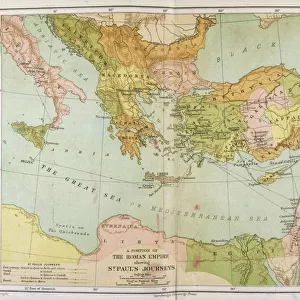
Antique Framed Print : Map of the Roman Empire 1889


![]()
Framed Photos from Fine Art Storehouse
Map of the Roman Empire 1889
Comprehensive Geography by James Monteith - American Book Company 1882, 1889
Unleash your creativity and transform your space into a visual masterpiece!
THEPALMER
Media ID 18357279
14"x12" (36x31cm) Antique Frame
Bevelled wood effect frame, card mounted, 10x8 archival quality photo print. Overall outside dimensions 14x12 inches (36x31cm). Environmentally and ozone friendly, the Polycore® moulding has the look of real wood, is durable and light and easy to hang. Biodegradable and made with non-chlorinated gases (no toxic fumes) it is efficient; producing 100 tons of polystyrene can save 300 tons of trees! Prints are glazed with lightweight, shatterproof, optical clarity acrylic (providing the same general protection from the environment as glass). The back is stapled hardboard with a sawtooth hanger attached. Note: To minimise original artwork cropping, for optimum layout, and to ensure print is secure, the visible print may be marginally smaller
Bevelled Wood Effect Framed and Mounted Prints - Professionally Made and Ready to Hang
Estimated Image Size (if not cropped) is 24.4cm x 17.8cm (9.6" x 7")
Estimated Product Size is 36.3cm x 31.2cm (14.3" x 12.3")
These are individually made so all sizes are approximate
Artwork printed orientated as per the preview above, with landscape (horizontal) orientation to match the source image.
FEATURES IN THESE COLLECTIONS
> Arts
> Artists
> R
> Roman Roman
> Historic
> Ancient civilizations
> Roman Empire
> Roman art
> Maps and Charts
> Related Images
> Fine Art Storehouse
> Map
> Historical Maps
EDITORS COMMENTS
This print showcases a remarkable piece of history - the "Map of the Roman Empire 1889". A true treasure for enthusiasts and scholars alike, this map was originally featured in James Monteith's renowned publication, "Comprehensive Geography" released by the American Book Company in 1882. The intricate details and meticulous craftsmanship of this map are brought to life through THEPALMER's exceptional photography. Transporting us back to an era long gone, this snapshot invites us to explore the vast expanse of one of history's greatest empires. From Britannia in the west to Mesopotamia in the east, every corner is meticulously charted with precision and accuracy. Each city, river, and mountain range is intricately labeled, providing a comprehensive understanding of Rome's expansive reach. The sepia tones add a touch of nostalgia to this already awe-inspiring artwork. As we gaze upon it, we can't help but marvel at how far humanity has come since those ancient times. It serves as a reminder that even great civilizations rise and fall but leave behind legacies that continue to shape our world today. Whether you're an avid historian or simply appreciate fine artistry, this print allows you to bring home a piece of ancient grandeur. Hang it on your wall or gift it to someone who shares your passion for exploration; either way, let yourself be transported back centuries as you immerse yourself in the splendorous Map of the Roman Empire from 1889 captured by THE
MADE IN THE UK
Safe Shipping with 30 Day Money Back Guarantee
FREE PERSONALISATION*
We are proud to offer a range of customisation features including Personalised Captions, Color Filters and Picture Zoom Tools
SECURE PAYMENTS
We happily accept a wide range of payment options so you can pay for the things you need in the way that is most convenient for you
* Options may vary by product and licensing agreement. Zoomed Pictures can be adjusted in the Basket.