Antique Framed Print > Maps and Charts > Africa
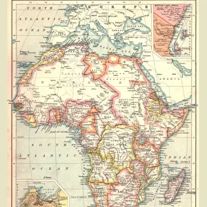
Antique Framed Print : Map of Africa 1900


![]()
Framed Photos from Fine Art Storehouse
Map of Africa 1900
Meyers hand-Atlas Leipzig und Wien Verlag des Bibliographischen Instituts 1900
Unleash your creativity and transform your space into a visual masterpiece!
THEPALMER
Media ID 18356595
14"x12" (36x31cm) Antique Frame
Bevelled wood effect frame, card mounted, 10x8 archival quality photo print. Overall outside dimensions 14x12 inches (36x31cm). Environmentally and ozone friendly, the Polycore® moulding has the look of real wood, is durable and light and easy to hang. Biodegradable and made with non-chlorinated gases (no toxic fumes) it is efficient; producing 100 tons of polystyrene can save 300 tons of trees! Prints are glazed with lightweight, shatterproof, optical clarity acrylic (providing the same general protection from the environment as glass). The back is stapled hardboard with a sawtooth hanger attached. Note: To minimise original artwork cropping, for optimum layout, and to ensure print is secure, the visible print may be marginally smaller
Bevelled Wood Effect Framed and Mounted Prints - Professionally Made and Ready to Hang
Estimated Image Size (if not cropped) is 20cm x 24.4cm (7.9" x 9.6")
Estimated Product Size is 31.2cm x 36.3cm (12.3" x 14.3")
These are individually made so all sizes are approximate
Artwork printed orientated as per the preview above, with portrait (vertical) orientation to match the source image.
FEATURES IN THESE COLLECTIONS
> Africa
> Related Images
> Fine Art Storehouse
> Map
> Historical Maps
EDITORS COMMENTS
In this print titled "Map of Africa 1900". THEPALMER takes us on a journey back in time to the turn of the century. The map, sourced from Meyers hand-Atlas Leipzig und Wien Verlag des Bibliographischen Instituts 1900, offers a fascinating glimpse into the African continent as it was known over a hundred years ago. The intricate details and delicate lines etched onto this vintage map evoke a sense of exploration and discovery. As we study its contours, we are transported to an era when cartography was both artistry and science, meticulously crafted by skilled hands. Africa's vastness is beautifully depicted here; from the Sahara Desert stretching across North Africa to the lush rainforests that dominate Central Africa. We can trace ancient trade routes along the Nile River and marvel at the mighty Victoria Falls cascading down Southern Africa. This historical document not only serves as a visual representation but also sparks curiosity about how borders have shifted, nations have emerged, and cultures have evolved since then. It invites us to reflect on our shared human history while appreciating the diversity that defines this magnificent continent. "The Map of Africa 1900" is more than just an artwork; it is a window into another time—a reminder of how far we've come and how much there still remains for us to explore.
MADE IN THE UK
Safe Shipping with 30 Day Money Back Guarantee
FREE PERSONALISATION*
We are proud to offer a range of customisation features including Personalised Captions, Color Filters and Picture Zoom Tools
SECURE PAYMENTS
We happily accept a wide range of payment options so you can pay for the things you need in the way that is most convenient for you
* Options may vary by product and licensing agreement. Zoomed Pictures can be adjusted in the Basket.