Antique Framed Print > Africa > Sudan > Maps
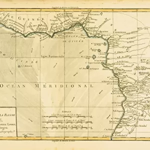
Antique Framed Print : Historical map of Upper-, Lower-Guinea and West-Sudan, lithograph, published 1897


![]()
Framed Photos from Fine Art Storehouse
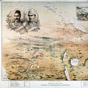
Historical map of Upper-, Lower-Guinea and West-Sudan, lithograph, published 1897
Historical map of Upper-, Lower-Guinea and West Suadn, West Africa. Lithograph, published in 1897
Unleash your creativity and transform your space into a visual masterpiece!
ZU_09
Media ID 18292323
21"x16" (54x41cm) Antique Frame
Bevelled wood effect frame, card mounted, 15x10 archival quality photo print. Overall outside dimensions 21x16 inches (54x41cm). Environmentally and ozone friendly, Polycore® moulding has the look of real wood, is durable and light and easy to hang. Biodegradable and made with non-chlorinated gases (no toxic fumes) it is efficient; producing 100 tons of polystyrene can save 300 tons of trees! Prints are glazed with lightweight, shatterproof, optical clarity acrylic (providing the same general protection from the environment as glass). The back is stapled hardboard with a sawtooth hanger attached. Note: To minimise original artwork cropping, for optimum layout, and to ensure print is secure, the visible print may be marginally smaller
Bevelled Wood Effect Framed and Mounted Prints - Professionally Made and Ready to Hang
Estimated Image Size (if not cropped) is 37.1cm x 22.2cm (14.6" x 8.7")
Estimated Product Size is 54cm x 41.4cm (21.3" x 16.3")
These are individually made so all sizes are approximate
Artwork printed orientated as per the preview above, with landscape (horizontal) orientation to match the source image.
FEATURES IN THESE COLLECTIONS
> Africa
> Guinea
> Related Images
> Africa
> Related Images
> Africa
> Sudan
> Related Images
> Maps and Charts
> Early Maps
> Maps and Charts
> Related Images
> Fine Art Storehouse
> Map
> Historical Maps
EDITORS COMMENTS
This lithograph, titled "Historical map of Upper-, Lower-Guinea and West-Sudan" takes us on a visual journey through the rich history of West Africa. Published in 1897, this intricate piece offers a glimpse into the region's past, showcasing its diverse geography and cultural heritage. The map is meticulously detailed, with delicate lines tracing the contours of rivers, mountains, and coastlines. It highlights important cities and trading routes that played significant roles in shaping the history of Upper Guinea, Lower Guinea, and West Sudan. As we study this print closely, we can almost feel ourselves transported back to a time when these lands were vibrant hubs of commerce and cultural exchange. The lithograph exudes an air of nostalgia as it captures the essence of a bygone era. Its sepia tones lend an antique charm to the artwork while evoking a sense of reverence for the historical significance it represents. The artist's skillful rendering brings life to each stroke on paper – every line telling stories untold. As we admire this remarkable piece from Fine Art Storehouse by ZU_09, our imagination runs wild with tales from ancient civilizations that once thrived across these lands. This print serves as both an educational tool for historians and a beautiful decorative item for art enthusiasts who appreciate not only aesthetic beauty but also value historical context within their collections.
MADE IN THE UK
Safe Shipping with 30 Day Money Back Guarantee
FREE PERSONALISATION*
We are proud to offer a range of customisation features including Personalised Captions, Color Filters and Picture Zoom Tools
SECURE PAYMENTS
We happily accept a wide range of payment options so you can pay for the things you need in the way that is most convenient for you
* Options may vary by product and licensing agreement. Zoomed Pictures can be adjusted in the Basket.