Antique Framed Print > Europe > Poland > Szczecin
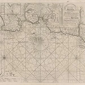
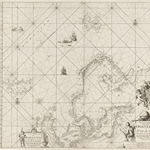
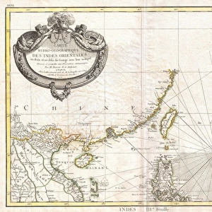
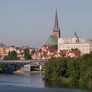
Antique Framed Print : Excerpts of nautical charts, lithograph, published in 1897


![]()
Framed Photos from Fine Art Storehouse
Excerpts of nautical charts, lithograph, published in 1897
Excerpts of nautical charts: I) Helgoland (Germany); II) Stettiner Haff (Szczecin Lagoon, Germany/Poland); III) North Sea. Lithograph, published in 1897
Unleash your creativity and transform your space into a visual masterpiece!
ZU_09
Media ID 18356505
14"x12" (36x31cm) Antique Frame
Bevelled wood effect frame, card mounted, 10x8 archival quality photo print. Overall outside dimensions 14x12 inches (36x31cm). Environmentally and ozone friendly, the Polycore® moulding has the look of real wood, is durable and light and easy to hang. Biodegradable and made with non-chlorinated gases (no toxic fumes) it is efficient; producing 100 tons of polystyrene can save 300 tons of trees! Prints are glazed with lightweight, shatterproof, optical clarity acrylic (providing the same general protection from the environment as glass). The back is stapled hardboard with a sawtooth hanger attached. Note: To minimise original artwork cropping, for optimum layout, and to ensure print is secure, the visible print may be marginally smaller
Bevelled Wood Effect Framed and Mounted Prints - Professionally Made and Ready to Hang
Estimated Image Size (if not cropped) is 17.1cm x 24.4cm (6.7" x 9.6")
Estimated Product Size is 31.2cm x 36.3cm (12.3" x 14.3")
These are individually made so all sizes are approximate
Artwork printed orientated as per the preview above, with portrait (vertical) orientation to match the source image.
FEATURES IN THESE COLLECTIONS
> Europe
> Germany
> Related Images
> Europe
> Poland
> Related Images
> Maps and Charts
> Related Images
> Fine Art Storehouse
> Map
> Historical Maps
EDITORS COMMENTS
This print showcases excerpts of nautical charts dating back to 1897. The lithograph, published over a century ago, offers a glimpse into the maritime world of that era. Divided into three sections, the charts highlight significant locations: Helgoland in Germany, Stettiner Haff (Szczecin Lagoon) spanning both Germany and Poland, and the vast North Sea. The first section focuses on Helgoland, an island known for its strategic location in the North Sea. The chart reveals intricate details of coastal lines and depths, providing invaluable information for sailors navigating these treacherous waters. Moving on to Stettiner Haff, this part of the lithograph captures the lagoon's complex network of channels and waterways. As an important trading route connecting various Baltic ports during that time period, this chart would have been indispensable for seafarers seeking safe passage through these challenging waters. Finally, we are presented with a broader view of the North Sea itself - a vast expanse teeming with maritime activity even then. This section encompasses multiple regions within this expansive body of water while highlighting key features such as currents and navigational hazards. Overall, this exquisite lithograph serves as both a historical artifact and an artistic representation of navigation in late 19th-century Europe. Its meticulous detailing transports us back to an era when maps were meticulously hand-drawn by skilled cartographers who relied on their expertise to guide ships safely across uncharted seas.
MADE IN THE UK
Safe Shipping with 30 Day Money Back Guarantee
FREE PERSONALISATION*
We are proud to offer a range of customisation features including Personalised Captions, Color Filters and Picture Zoom Tools
SECURE PAYMENTS
We happily accept a wide range of payment options so you can pay for the things you need in the way that is most convenient for you
* Options may vary by product and licensing agreement. Zoomed Pictures can be adjusted in the Basket.