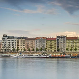
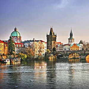
Antique Framed Print > Europe > Czech Republic > Heritage Sites > Historic Centre of Prague
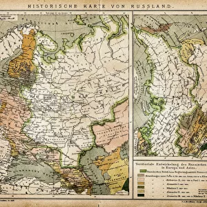
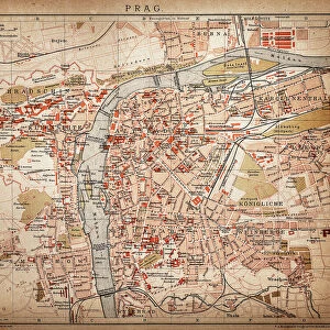
Antique Framed Print : North German lowland map, 19th century view, lithograph, published 1884


![]()
Framed Photos from Fine Art Storehouse
North German lowland map, 19th century view, lithograph, published 1884
Old Topographic map of the North German lowland in German language. Lithograph, published in 1884
Unleash your creativity and transform your space into a visual masterpiece!
Media ID 14756494
© This content is subject to copyright
Baltic Sea Berlin Bohemia Cologne Colorful Copenhagen Czech Republic Danzig Denmark Elbe River European Culture Gdansk German Culture Hamburg Kaliningrad Krakow Lowland North German North Sea Poland Prague Prussia Rhine Scandinavia Stuttgart Topographic Map Warsaw Wroclaw Breslau Bromberg Dnsseldorf Frankfurt Konigsberg Oder Posen Poznan Riesengebirge Sudeten
14"x12" (36x31cm) Antique Frame
Bevelled wood effect frame, card mounted, 10x8 archival quality photo print. Overall outside dimensions 14x12 inches (36x31cm). Environmentally and ozone friendly, the Polycore® moulding has the look of real wood, is durable and light and easy to hang. Biodegradable and made with non-chlorinated gases (no toxic fumes) it is efficient; producing 100 tons of polystyrene can save 300 tons of trees! Prints are glazed with lightweight, shatterproof, optical clarity acrylic (providing the same general protection from the environment as glass). The back is stapled hardboard with a sawtooth hanger attached. Note: To minimise original artwork cropping, for optimum layout, and to ensure print is secure, the visible print may be marginally smaller
Bevelled Wood Effect Framed and Mounted Prints - Professionally Made and Ready to Hang
Estimated Image Size (if not cropped) is 24.4cm x 17.9cm (9.6" x 7")
Estimated Product Size is 36.3cm x 31.2cm (14.3" x 12.3")
These are individually made so all sizes are approximate
Artwork printed orientated as per the preview above, with landscape (horizontal) orientation to match the source image.
FEATURES IN THESE COLLECTIONS
> Arts
> Landscape paintings
> Landscape art
> Landscape paintings
> Arts
> Landscape paintings
> Waterfall and river artworks
> Landscape paintings
> Arts
> Landscape paintings
> Waterfall and river artworks
> River artworks
> Europe
> Czech Republic
> Heritage Sites
> Historic Centre of Prague
> Europe
> Czech Republic
> Maps
> Europe
> Czech Republic
> Posters
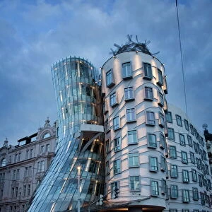
> Europe
> Czech Republic
> Prague
> Europe
> Czech Republic
> Related Images
> Europe
> Czech Republic
> Rivers
> Europe
> Denmark
> Copenhagen
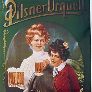
> Fine Art Storehouse
> Map
> Denmark Maps
> Fine Art Storehouse
> Map
> Historical Maps
EDITORS COMMENTS
This lithograph, dating back to 1884, offers a mesmerizing glimpse into the North German lowland during the 19th century. The intricate details of this topographic map provide an invaluable historical perspective on the region's geography and cultural significance. Stretching from Germany to Poland and the Czech Republic, this expansive landscape encompasses iconic cities such as Berlin, Prague, Hamburg, Königsberg (now Kaliningrad), and Gdansk. As you explore this vibrant print, your eyes will be drawn to major rivers like the Elbe and Rhine that meander through these lands. The presence of Copenhagen hints at Denmark's proximity while emphasizing Scandinavia's influence in shaping regional dynamics. Prussia also finds its place on this map alongside Warsaw, Bromberg (Bydgoszcz), Cologne, Frankfurt, Wroclaw (Breslau), Posen (Poznan), Krakow, Stuttgart – each city contributing its unique charm to European culture. The surrounding seas - North Sea and Baltic Sea - play a crucial role in connecting these lands with neighboring countries across Europe. From Sudeten Mountains to Riesengebirge range in Bohemia; every contour is meticulously engraved onto this colorful lithograph. Transport yourself back in time by admiring this old-world artwork that beautifully captures the essence of an era long gone. Whether you are a history enthusiast or simply appreciate fine art prints like these for their aesthetic appeal; let your imagination wander as you delve into the rich
MADE IN THE UK
Safe Shipping with 30 Day Money Back Guarantee
FREE PERSONALISATION*
We are proud to offer a range of customisation features including Personalised Captions, Color Filters and Picture Zoom Tools
SECURE PAYMENTS
We happily accept a wide range of payment options so you can pay for the things you need in the way that is most convenient for you
* Options may vary by product and licensing agreement. Zoomed Pictures can be adjusted in the Basket.