Antique Framed Print > Fine Art Storehouse > Map
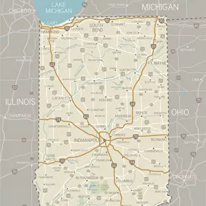
Antique Framed Print : Map of Kentucky and Tennessee


![]()
Framed Photos from Fine Art Storehouse
Map of Kentucky and Tennessee
Map of Kentucky and Tennessee - 1886 scanned engraving
Unleash your creativity and transform your space into a visual masterpiece!
benoitb
Media ID 13667275
© This content is subject to copyright
American Civil War Canada Kentucky Mississippi River Sketch State Tennessee Classical Style Nashville Tennessee River Victorian Style
21"x16" (54x41cm) Antique Frame
Bevelled wood effect frame, card mounted, 15x10 archival quality photo print. Overall outside dimensions 21x16 inches (54x41cm). Environmentally and ozone friendly, Polycore® moulding has the look of real wood, is durable and light and easy to hang. Biodegradable and made with non-chlorinated gases (no toxic fumes) it is efficient; producing 100 tons of polystyrene can save 300 tons of trees! Prints are glazed with lightweight, shatterproof, optical clarity acrylic (providing the same general protection from the environment as glass). The back is stapled hardboard with a sawtooth hanger attached. Note: To minimise original artwork cropping, for optimum layout, and to ensure print is secure, the visible print may be marginally smaller
Bevelled Wood Effect Framed and Mounted Prints - Professionally Made and Ready to Hang
Estimated Image Size (if not cropped) is 37.1cm x 25.2cm (14.6" x 9.9")
Estimated Product Size is 54cm x 41.4cm (21.3" x 16.3")
These are individually made so all sizes are approximate
Artwork printed orientated as per the preview above, with landscape (horizontal) orientation to match the source image.
FEATURES IN THESE COLLECTIONS
> Fine Art Storehouse
> History
> Battles & Wars
> American Civil War (1860-1865)
> Fine Art Storehouse
> Map
> Historical Maps
> Fine Art Storehouse
> Map
> USA Maps
EDITORS COMMENTS
This print takes us back in time to the year 1886, where we find ourselves immersed in a detailed map of Kentucky and Tennessee. The scanned engraving showcases the intricate craftsmanship of this historical piece, capturing the essence of an era long gone. The map itself is a testament to the significance of these two states during the American Civil War. It highlights key landmarks such as the Mississippi River, Nashville, and the Tennessee River, reminding us of their strategic importance during that tumultuous period in history. Rendered in a Victorian style with classical influences, this engraved image transports us to a bygone era when maps were meticulously hand-drawn works of art. Its antique charm evokes nostalgia for simpler times and invites us to explore every intricate detail etched onto its surface. As we gaze upon this remarkable print against its pristine white background, we are reminded not only of our rich past but also how far we have come since then. This 19th-century masterpiece serves as a visual reminder of our shared history and offers an opportunity for reflection on how it has shaped our present-day world. Benoitb's skillful preservation and presentation allow us to appreciate this historical gem anew while honoring its timeless beauty.
MADE IN THE UK
Safe Shipping with 30 Day Money Back Guarantee
FREE PERSONALISATION*
We are proud to offer a range of customisation features including Personalised Captions, Color Filters and Picture Zoom Tools
SECURE PAYMENTS
We happily accept a wide range of payment options so you can pay for the things you need in the way that is most convenient for you
* Options may vary by product and licensing agreement. Zoomed Pictures can be adjusted in the Basket.