Antique Framed Print > Africa > South Africa > Maps
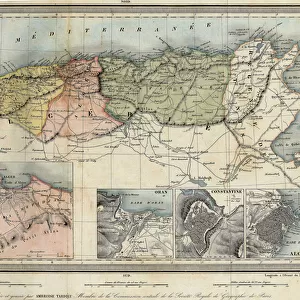
Antique Framed Print : Historic Map of Cape Town, South Africa


![]()
Framed Photos from Fine Art Finder
Historic Map of Cape Town, South Africa
7279490 Historic Map of Cape Town, South Africa by Unknown Artist, (19th century); Private Collection; (add.info.: Historic Map of Cape Town, South Africa, Historic, digitally restored reproduction of an original 19th century map, Africa); © Imagebroker
Media ID 28002062
© Imagebroker / Bridgeman Images
14"x12" (36x31cm) Antique Frame
Bevelled wood effect frame, card mounted, 10x8 archival quality photo print. Overall outside dimensions 14x12 inches (36x31cm). Environmentally and ozone friendly, the Polycore® moulding has the look of real wood, is durable and light and easy to hang. Biodegradable and made with non-chlorinated gases (no toxic fumes) it is efficient; producing 100 tons of polystyrene can save 300 tons of trees! Prints are glazed with lightweight, shatterproof, optical clarity acrylic (providing the same general protection from the environment as glass). The back is stapled hardboard with a sawtooth hanger attached. Note: To minimise original artwork cropping, for optimum layout, and to ensure print is secure, the visible print may be marginally smaller
Bevelled Wood Effect Framed and Mounted Prints - Professionally Made and Ready to Hang
Estimated Image Size (if not cropped) is 24.4cm x 20.6cm (9.6" x 8.1")
Estimated Product Size is 36.3cm x 31.2cm (14.3" x 12.3")
These are individually made so all sizes are approximate
Artwork printed orientated as per the preview above, with landscape (horizontal) orientation to match the source image.
FEATURES IN THESE COLLECTIONS
> Africa
> Related Images
> Africa
> South Africa
> Cape Town
> Africa
> South Africa
> Maps
> Africa
> South Africa
> Related Images
> Maps and Charts
> Early Maps
> Maps and Charts
> Related Images
> Fine Art Finder
> Artists
> Unknown Artist
EDITORS COMMENTS
This print showcases a "Historic Map of Cape Town, South Africa" from the 19th century. Created by an unknown artist, this digitally restored reproduction provides a glimpse into the rich cartography and vibrant colors of that era. The map is part of a private collection and offers valuable insights into the history and geography of Cape Town. The intricate illustration takes us back to a time when exploration and discovery were at their peak. With its detailed depictions, it allows us to imagine what life was like in this bustling African city during the 19th century. From its early days to its growth as an important trading hub, Cape Town's significance is beautifully captured on this map. The use of color adds depth and character to the artwork, highlighting different regions and landmarks within Cape Town. This visual representation not only serves as a historical document but also as an exquisite piece of art that can be admired for its aesthetic appeal. As we delve into this fascinating piece, we are reminded of how maps have always been essential tools for understanding our world. They provide us with invaluable knowledge about distant lands while igniting our curiosity for exploration. Sunny Celeste's skillful capture ensures that this historic map continues to inspire awe and appreciation for both the artistry involved in creating it and the story it tells about one of Africa's most iconic cities.
MADE IN THE UK
Safe Shipping with 30 Day Money Back Guarantee
FREE PERSONALISATION*
We are proud to offer a range of customisation features including Personalised Captions, Color Filters and Picture Zoom Tools
SECURE PAYMENTS
We happily accept a wide range of payment options so you can pay for the things you need in the way that is most convenient for you
* Options may vary by product and licensing agreement. Zoomed Pictures can be adjusted in the Basket.