Antique Framed Print > Arts > Artists > H > Hungarian School Hungarian School
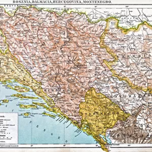
Antique Framed Print : Map of the Austro-Hungarian empire, illustration from a French geography school textbook


![]()
Framed Photos from Fine Art Finder
Map of the Austro-Hungarian empire, illustration from a French geography school textbook
CHT220347 Map of the Austro-Hungarian empire, illustration from a French geography school textbook, 1905 (colour litho) by French School, (20th century); Private Collection; (add.info.: La 3eme Annee de Geographie de P. Foncin, Librairie Armand Colin, Paris; ); eArchives Charmet; French, out of copyright
Media ID 22663750
© Archives Charmet / Bridgeman Images
Austria Hungary Bohemia Bosnia Bosniaque Croatia Dalmatia Galicia Habsbourg Habsburg Hapsburg Herzegovina Romania Rumania Styria Transylvania Carinthia Illyria
14"x12" (36x31cm) Antique Frame
Bevelled wood effect frame, card mounted, 10x8 archival quality photo print. Overall outside dimensions 14x12 inches (36x31cm). Environmentally and ozone friendly, the Polycore® moulding has the look of real wood, is durable and light and easy to hang. Biodegradable and made with non-chlorinated gases (no toxic fumes) it is efficient; producing 100 tons of polystyrene can save 300 tons of trees! Prints are glazed with lightweight, shatterproof, optical clarity acrylic (providing the same general protection from the environment as glass). The back is stapled hardboard with a sawtooth hanger attached. Note: To minimise original artwork cropping, for optimum layout, and to ensure print is secure, the visible print may be marginally smaller
Bevelled Wood Effect Framed and Mounted Prints - Professionally Made and Ready to Hang
Estimated Image Size (if not cropped) is 24.4cm x 20.4cm (9.6" x 8")
Estimated Product Size is 36.3cm x 31.2cm (14.3" x 12.3")
These are individually made so all sizes are approximate
Artwork printed orientated as per the preview above, with landscape (horizontal) orientation to match the source image.
FEATURES IN THESE COLLECTIONS
> Arts
> Artists
> H
> Hungarian School Hungarian School
> Europe
> Austria
> Related Images
> Europe
> Bosnia and Herzegovina
> Maps
> Europe
> Croatia
> Related Images
> Europe
> France
> Paris
> Maps
> Fine Art Finder
> Artists
> French School
> Fine Art Finder
> Artists
> School Romanian
> Fine Art Finder
> Maps (celestial & Terrestrial)
EDITORS COMMENTS
This print showcases a beautifully detailed map of the Austro-Hungarian empire, taken from a French geography school textbook dating back to 1905. The vibrant colors and intricate lithography bring this historical illustration to life, offering us a glimpse into the past. The map highlights various regions within the empire, including Transylvania, Galicia, Carinthia, Bosnia, Dalmatia, Romania, Bohemia, Styria, Croatia and more. It also features significant landmarks such as Hapsburg palaces and notable cities throughout Austria-Hungary. As we delve into this visual representation of European history, we can sense the grandeur and complexity of this once-mighty empire. The Austro-Hungarian empire was known for its diverse cultures and ethnicities that coexisted within its borders. This print not only serves as an educational tool but also evokes a sense of nostalgia for a bygone era. It reminds us of the importance of understanding our shared history and appreciating how it has shaped our present-day world. With its rich colors and meticulous details captured through lithography techniques in early 20th-century France; this image is truly a treasure from another time. Its presence in private collections allows us to appreciate both the artistic value and historical significance it holds. Let this mesmerizing map transport you back in time as you explore the vast territories that once made up one of Europe's most influential empires - the Austro-Hungarian Empire.
MADE IN THE UK
Safe Shipping with 30 Day Money Back Guarantee
FREE PERSONALISATION*
We are proud to offer a range of customisation features including Personalised Captions, Color Filters and Picture Zoom Tools
SECURE PAYMENTS
We happily accept a wide range of payment options so you can pay for the things you need in the way that is most convenient for you
* Options may vary by product and licensing agreement. Zoomed Pictures can be adjusted in the Basket.