Antique Framed Print > Arts > Artists > L > Guillaume Le Testu
Antique Framed Print : Fol. 47v Map of Peru, from Cosmographie Universelle, 1555 (w / c on paper)
")
")


![]()
Framed Photos from Fine Art Finder
Fol. 47v Map of Peru, from Cosmographie Universelle, 1555 (w / c on paper)
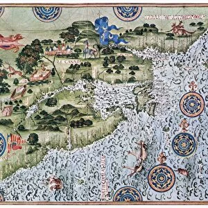
XIR165901 Fol.47v Map of Peru, from Cosmographie Universelle, 1555 (w/c on paper) by Le Testu, Guillaume (c.1509-73); Min. Defense - Service Historique de l Armee de Terre, France; French, out of copyright
Media ID 12735903
© www.bridgemanimages.com
Compass Pacific Ocean Native Animal
14"x12" (36x31cm) Antique Frame
Bevelled wood effect frame, card mounted, 10x8 archival quality photo print. Overall outside dimensions 14x12 inches (36x31cm). Environmentally and ozone friendly, the Polycore® moulding has the look of real wood, is durable and light and easy to hang. Biodegradable and made with non-chlorinated gases (no toxic fumes) it is efficient; producing 100 tons of polystyrene can save 300 tons of trees! Prints are glazed with lightweight, shatterproof, optical clarity acrylic (providing the same general protection from the environment as glass). The back is stapled hardboard with a sawtooth hanger attached. Note: To minimise original artwork cropping, for optimum layout, and to ensure print is secure, the visible print may be marginally smaller
Bevelled Wood Effect Framed and Mounted Prints - Professionally Made and Ready to Hang
Estimated Image Size (if not cropped) is 18cm x 24.4cm (7.1" x 9.6")
Estimated Product Size is 31.2cm x 36.3cm (12.3" x 14.3")
These are individually made so all sizes are approximate
Artwork printed orientated as per the preview above, with portrait (vertical) orientation to match the source image.
FEATURES IN THESE COLLECTIONS
> Arts
> Artists
> L
> Guillaume Le Testu
> Fine Art Finder
> Artists
> Guillaume Le Testu
> Fine Art Finder
> Maps (celestial & Terrestrial)
EDITORS COMMENTS
This print showcases Fol. 47v Map of Peru, a remarkable piece from the renowned Cosmographie Universelle collection dating back to 1555. Created by the talented Guillaume Le Testu, this watercolor on paper masterpiece offers a fascinating glimpse into the rich history and geography of Peru. The map itself is an intricate depiction of Peru's landscape, featuring its majestic coastline along the Pacific Ocean. The attention to detail is evident as it highlights various landmarks and regions with precision. A compass elegantly adorns the map, emphasizing its navigational significance during that era. Adding depth and character to this artwork are native animals scattered throughout the composition. These creatures not only lend authenticity but also provide insight into Peru's diverse wildlife. A flag proudly waves in one corner, symbolizing national pride and identity. It serves as a reminder of Peru's historical importance and contributions to South America. This extraordinary print captures every nuance of Le Testu's original work with stunning clarity and vibrancy. Its inclusion in prestigious archives such as Min. Defense - Service Historique de l'Armee de Terre in France further attests to its historical value. As you explore this image, allow yourself to be transported back in time; immerse yourself in the beauty and intricacy of this ancient cartographic treasure – a true testament to human curiosity and exploration.
MADE IN THE UK
Safe Shipping with 30 Day Money Back Guarantee
FREE PERSONALISATION*
We are proud to offer a range of customisation features including Personalised Captions, Color Filters and Picture Zoom Tools
SECURE PAYMENTS
We happily accept a wide range of payment options so you can pay for the things you need in the way that is most convenient for you
* Options may vary by product and licensing agreement. Zoomed Pictures can be adjusted in the Basket.