Acrylic Blox > Popular Themes > Railway Posters
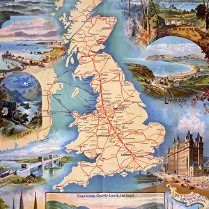
Acrylic Blox : Railway map of Britain


![]()
Mounted Prints from Mary Evans Picture Library
Railway map of Britain
Philips railway map of the British Isles, c1923 Date: c. 1923
Mary Evans Picture Library makes available wonderful images created for people to enjoy over the centuries
Media ID 7401941
© Mary Evans Picture Library 2015 - https://copyrighthub.org/s0/hub1/creation/maryevans/MaryEvansPictureID/10474748
8"x6" (20x15cm) Acrylic Blox
Your photographic print is held in place by magnets and a micro thin sheet of metal covering the back of a 20mm piece of clear acrylic. Your print is held in place with magnets so can easily be replaced if needed.
Streamlined, one sided modern and attractive table top print
Estimated Product Size is 15.2cm x 20.3cm (6" x 8")
These are individually made so all sizes are approximate
Artwork printed orientated as per the preview above, with portrait (vertical) orientation to match the source image.
FEATURES IN THESE COLLECTIONS
> Maps and Charts
> Related Images
> Popular Themes
> Railway Posters
> Mary Evans Prints Online
> National Archives
EDITORS COMMENTS
1. Title: "Voyage Through Time: Exploring the Philips Railway Map of the British Isles (1923)" Step back in time and embark on a captivating journey through the heart of 1920s Britain with this exquisite Philips Railway Map of the British Isles, dated circa 1923. This print, available from Mary Evans Prints Online, offers a unique glimpse into the transport infrastructure of a bygone era. The map, adorned with intricate details, meticulously illustrates the extensive railway network that connected the diverse regions of Britain during the 1920s. The vibrant colors and clear, easy-to-read labels make it an essential tool for travelers and an intriguing piece of historical art. The map features not only the major railway lines but also the branch lines, ferry connections, and even the locations of various railway stations. This comprehensive representation of the British railway system during the 1920s serves as a testament to the remarkable advancements in transportation technology and infrastructure during this period. The Philips Railway Map of the British Isles is more than just a map; it's a window into the past. It invites us to explore the rich history of travel and transportation in Britain during the 1920s, a time when the country was undergoing significant social, economic, and cultural changes. As you study the intricate details of this stunning print, you'll be transported back to a time when the world moved a little slower, and the simple joy of planning a journey by rail was an adventure in itself. This map is a must-have for history enthusiasts, railway aficionados, and anyone with a fascination for the history of transportation. So, take a moment to immerse yourself in the captivating world of the Philips Railway Map of the British Isles, circa 1923. Let the allure of the 1920s transport you on an unforgettable journey through time.
MADE IN THE UK
Safe Shipping with 30 Day Money Back Guarantee
FREE PERSONALISATION*
We are proud to offer a range of customisation features including Personalised Captions, Color Filters and Picture Zoom Tools
SECURE PAYMENTS
We happily accept a wide range of payment options so you can pay for the things you need in the way that is most convenient for you
* Options may vary by product and licensing agreement. Zoomed Pictures can be adjusted in the Basket.