Acrylic Blox > Arts > Photorealistic artworks > Meticulous attention to detail > Detailed artwork
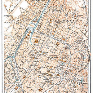
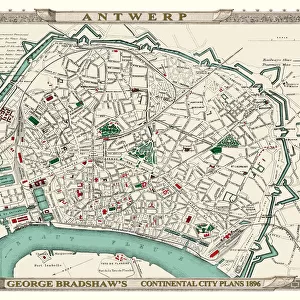
Acrylic Blox : George Bradshaws Plan of Ostend, Belgium 1896


![]()
Mounted Prints from MapSeeker
George Bradshaws Plan of Ostend, Belgium 1896
This is a detailed Plan of Ostend showing the streets, canals, principal buildings, railways and railway stations. It has been meticulously recreated in colour and republished without and fold creases by Mapseeker, from a rare antique original black and white fold up tourist city map. The 29 that were originally published as fold up maps featuring the principal cities of Europe are now rare, yet popular at their time among those who could then explore Europe by railway for the first time
Welcome to the Mapseeker Image library and enter an historic gateway to one of the largest on-line collections of Historic Maps, Nostalgic Views, Vista's and Panorama's from a World gone by.
Media ID 20347987
© Mapseeker Publishing Ltd
Bradshaw City Map Bradshaw City Plan Bradshaw Map Europe City Europe City Plan European City Map European City Plan Historic Map Old Town Plan Brussels
6"x4" (15x10cm) Acrylic Blox
Your photographic print is held in place by magnets and a micro thin sheet of metal covering the back of a 20mm piece of clear acrylic. Your print is held in place with magnets so can easily be replaced if needed.
Streamlined, one sided modern and attractive table top print
Estimated Product Size is 15.2cm x 10.2cm (6" x 4")
These are individually made so all sizes are approximate
Artwork printed orientated as per the preview above, with landscape (horizontal) orientation to match the source image.
FEATURES IN THESE COLLECTIONS
> Arts
> Artists
> W
> George White
> Arts
> Modern art pieces
> Pop art
> Street art
> Arts
> Photorealistic artworks
> Detailed art pieces
> Masterful detailing in art
> Arts
> Photorealistic artworks
> Meticulous attention to detail
> Detailed artwork
> Arts
> Photorealistic artworks
> Meticulous attention to detail
> Fine art
> MapSeeker
> Maps of Europe
> Maps of Belgium PORTFOLIO
EDITORS COMMENTS
This vibrant and meticulously recreated print showcases George Bradshaw's Plan of Ostend, Belgium in 1896. A true treasure for history enthusiasts and map collectors alike, this detailed plan offers a glimpse into the past with its depiction of streets, canals, principal buildings, railways, and railway stations. Originally published as one of the 29 fold up maps featuring Europe's principal cities, these maps were highly sought after by those embarking on their first European railway adventures. Mapseeker Publishing Ltd has taken great care to reproduce this rare antique original without any fold creases and in vivid color. The result is a stunning piece that captures the essence of Ostend during that era. This old town plan not only serves as a visual delight but also provides valuable insights into the city's layout and infrastructure at the time. As you explore this historic map of Ostend, you'll be transported back to an era when railways were revolutionizing travel across Europe. Immerse yourself in the intricate details that showcase every street corner and canal bend with precision. Whether you're a history buff or simply appreciate beautiful cartography, this George Bradshaw creation is sure to captivate your imagination. Discover Ostend through the eyes of George Bradshaw with this exceptional print from MapSeeker – an exquisite addition to any collection celebrating heritage maps or offering a unique perspective on Belgium's captivating coastal city.
MADE IN THE UK
Safe Shipping with 30 Day Money Back Guarantee
FREE PERSONALISATION*
We are proud to offer a range of customisation features including Personalised Captions, Color Filters and Picture Zoom Tools
SECURE PAYMENTS
We happily accept a wide range of payment options so you can pay for the things you need in the way that is most convenient for you
* Options may vary by product and licensing agreement. Zoomed Pictures can be adjusted in the Basket.