Acrylic Blox > Europe > United Kingdom > England > London > Art > Theatre
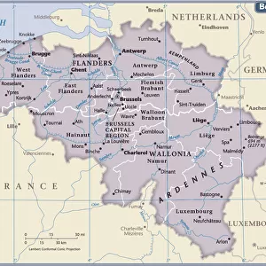
Acrylic Blox : Map showing the Canal System connecting Zeebrugge and Ostend with Bruges... (c1920)
")
")


![]()
Mounted Prints from Heritage Images
Map showing the Canal System connecting Zeebrugge and Ostend with Bruges... (c1920)
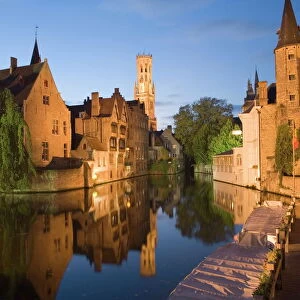
Map showing the Canal System connecting Zeebrugge and Ostend with Bruges, First World War, (c1920). The Belgian ports of Ostend and Zeebrugge were connected to the city of Bruges via canals. From " The Great World War: A History", Volume IX, edited by Frank A Mumby. [The Gresham Publishing Company Ltd, London, c1920]
Heritage Images features heritage image collections
Media ID 19666049
© The Print Collector/Heritage Images
Bruges Bruges Flanders Belgium Canal Canals Coastline Frank A Frank A Mumby Frank Arthur Frank Arthur Mumby Gresham Publishing Co Ltd Gresham Publishing Company Keystone Archives Mumby Mumby Frank A Mumby Frank Arthur Network North Sea Ostend Ostend Belgium Ostende The Great World War A History Theatre Of War Zeebrugge
6"x4" (15x10cm) Acrylic Blox
Your photographic print is held in place by magnets and a micro thin sheet of metal covering the back of a 20mm piece of clear acrylic. Your print is held in place with magnets so can easily be replaced if needed.
Streamlined, one sided modern and attractive table top print
Estimated Product Size is 15.2cm x 10.2cm (6" x 4")
These are individually made so all sizes are approximate
Artwork printed orientated as per the preview above, with landscape (horizontal) orientation to match the source image.
FEATURES IN THESE COLLECTIONS
> Animals
> Mammals
> Muridae
> Water Mouse
> Europe
> Belgium
> Related Images
> Europe
> United Kingdom
> England
> London
> Art
> Theatre
> Historic
> World War I and II
> World War I
> Historic
> World War I and II
> Maps and Charts
> Related Images
EDITORS COMMENTS
This print showcases a historical map from the early 20th century, depicting the intricate canal system that connected Zeebrugge and Ostend with Bruges in Belgium. The map, which dates back to the First World War era, offers a fascinating glimpse into the geographical features of this coastal region. The Belgian ports of Ostend and Zeebrugge played crucial roles during this tumultuous period, serving as vital transportation hubs for military operations. The canals depicted on the map provided an efficient network for water transport, enabling swift movement of troops and supplies between these strategic locations. As we delve into this piece from "The Great World War: A History" edited by Frank A Mumby, we are transported back in time to witness how these canals served as lifelines during one of history's most significant conflicts. This image not only highlights their importance but also emphasizes the ingenuity behind their construction. With its detailed representation of Bruges' connection to Ostend and Zeebrugge via canals, this print serves as a testament to human resilience amidst war. It reminds us of the immense challenges faced by those involved in transporting resources across vast distances while navigating treacherous waters. Preserved through time by The Gresham Publishing Company Ltd. , London, this photograph captures both the historical significance and beauty inherent in maps from yesteryears. As we gaze upon it today, we gain a deeper appreciation for how geography shaped warfare strategies during World War I while marveling at our ancestors' ability to create such intricate systems within nature's boundaries.
MADE IN THE UK
Safe Shipping with 30 Day Money Back Guarantee
FREE PERSONALISATION*
We are proud to offer a range of customisation features including Personalised Captions, Color Filters and Picture Zoom Tools
SECURE PAYMENTS
We happily accept a wide range of payment options so you can pay for the things you need in the way that is most convenient for you
* Options may vary by product and licensing agreement. Zoomed Pictures can be adjusted in the Basket.