Acrylic Blox > Europe > Belgium > Maps
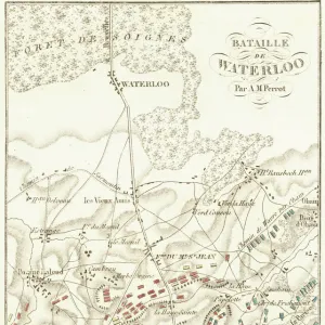
Acrylic Blox : WORLD WAR I: BELGIUM, 1918. Map showing the zone of war operations in western Belgium


![]()
Mounted Prints from Granger
WORLD WAR I: BELGIUM, 1918. Map showing the zone of war operations in western Belgium
WORLD WAR I: BELGIUM, 1918.
Map showing the zone of war operations in western Belgium, the ports of Ostend and Zeebrugge, the line of battle on 28 September 1918, and the line to which the Belgians had advanced ten days later
Granger holds millions of images spanning more than 25,000 years of world history, from before the Stone Age to the dawn of the Space Age
Media ID 12405344
1918 Battle Belgian Belgium Canal Road September Warfare Western Western Front World War I Ypres
8"x6" (20x15cm) Acrylic Blox
Your photographic print is held in place by magnets and a micro thin sheet of metal covering the back of a 20mm piece of clear acrylic. Your print is held in place with magnets so can easily be replaced if needed.
Streamlined, one sided modern and attractive table top print
Estimated Product Size is 20.3cm x 15.2cm (8" x 6")
These are individually made so all sizes are approximate
Artwork printed orientated as per the preview above, with landscape (horizontal) orientation to match the source image.
FEATURES IN THESE COLLECTIONS
> Europe
> Belgium
> Related Images
> Historic
> Battles
> Related Images
> Historic
> World War I and II
> World War I
> Maps and Charts
> Early Maps
> Maps and Charts
> Related Images
> Maps and Charts
> World
> Granger Art on Demand
> 20th Century Wars
World War I - Belgium, 1918 - A Historic Map Unveiling the Zone of War Operations and Belgian Advancements
EDITORS COMMENTS
. This sepia-toned print takes us back to the tumultuous era of World War I in Belgium. The intricate map showcased here reveals the extensive zone of war operations that engulfed western Belgium during this period. It highlights key landmarks such as the strategic ports of Ostend and Zeebrugge, which played crucial roles in shaping the outcome of battles. Dated September 28,1918, this map also depicts the precise line of battle at that time. It offers a glimpse into the fierce warfare tactics employed by both sides along this Western Front. Additionally, it showcases how ten days later, brave Belgian forces had managed to advance significantly towards their objectives. The historical significance of this image lies not only in its portrayal of military movements but also in its ability to transport us back to an early stage of modern warfare. Through detailed text annotations on roads and canals, we gain insight into how these geographical features influenced tactical decisions made by commanders on both sides. As a valuable piece from Granger Art on Demand collection, this print serves as a poignant reminder of the sacrifices made during World War I while offering a unique perspective on one specific theater within Belgium's war-torn landscape.
MADE IN THE UK
Safe Shipping with 30 Day Money Back Guarantee
FREE PERSONALISATION*
We are proud to offer a range of customisation features including Personalised Captions, Color Filters and Picture Zoom Tools
SECURE PAYMENTS
We happily accept a wide range of payment options so you can pay for the things you need in the way that is most convenient for you
* Options may vary by product and licensing agreement. Zoomed Pictures can be adjusted in the Basket.