Acrylic Blox > Europe > Austria > Maps
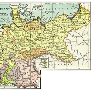
Acrylic Blox : Map of Europe 1897


![]()
Mounted Prints from Fine Art Storehouse
Map of Europe 1897
Natural Elementary Geography by Redway and Hinman - NY/Cincinnati/Chicago 1897
Unleash your creativity and transform your space into a visual masterpiece!
THEPALMER
Media ID 15133652
© This content is subject to copyright
Austria Denmark Norway Portugal Russia Sweden
8"x6" (20x15cm) Acrylic Blox
Your photographic print is held in place by magnets and a micro thin sheet of metal covering the back of a 20mm piece of clear acrylic. Your print is held in place with magnets so can easily be replaced if needed.
Streamlined, one sided modern and attractive table top print
Estimated Product Size is 15.2cm x 20.3cm (6" x 8")
These are individually made so all sizes are approximate
Artwork printed orientated as per the preview above, with portrait (vertical) orientation to match the source image.
FEATURES IN THESE COLLECTIONS
> Europe
> Austria
> Related Images
> Europe
> Denmark
> Related Images
> Europe
> Germany
> Related Images
> Fine Art Storehouse
> Map
> Denmark Maps
> Fine Art Storehouse
> Map
> Historical Maps
> Fine Art Storehouse
> Map
> Italian Maps
EDITORS COMMENTS
In this print titled "Map of Europe 1897" we are transported back in time to an era when cartography was both a science and an art form. The map, originally featured in the renowned textbook "Natural Elementary Geography" by Redway and Hinman, takes us on a journey through the diverse lands of Europe. The intricate details of this vintage map allow us to explore the political boundaries, geographical features, and cultural nuances that defined Europe at the turn of the 19th century. From Portugal's sun-kissed shores to Russia's vast expanse, each country is meticulously outlined with precision and care. As we study this historical artifact, our eyes are drawn to notable nations such as France, Germany, Italy, Spain, Austria, Denmark, Norway, Sweden - all interconnected like puzzle pieces forming a complex tapestry of European identity. This visual representation serves as a reminder of how these countries have evolved over time while still retaining their unique heritage. "The Map of Europe 1897" by THEPALMER captures not only geography but also nostalgia for a bygone era. It invites us to reflect on how borders have shifted and alliances formed throughout history. Whether displayed in an educational setting or cherished within one's personal collection; this timeless artwork sparks curiosity about our past while igniting appreciation for the craftsmanship behind antique maps.
MADE IN THE UK
Safe Shipping with 30 Day Money Back Guarantee
FREE PERSONALISATION*
We are proud to offer a range of customisation features including Personalised Captions, Color Filters and Picture Zoom Tools
SECURE PAYMENTS
We happily accept a wide range of payment options so you can pay for the things you need in the way that is most convenient for you
* Options may vary by product and licensing agreement. Zoomed Pictures can be adjusted in the Basket.