Acrylic Blox > Europe > Iceland > Maps
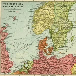
Acrylic Blox : Antique Map of Sweden, Norway and Denmark


![]()
Mounted Prints from Fine Art Storehouse
Antique Map of Sweden, Norway and Denmark
Vintage map of Sweden, Norway and Denmark, from 1894
Unleash your creativity and transform your space into a visual masterpiece!
duncan1890
Media ID 13597636
© duncan1890
1890 1899 Denmark Iceland Image Created 1890 1899 Navigational Equipment Nordic Countries Northern Europe Norway Past Retro Revival Scandinavia Sweden Image Created 19th Century Obsolete Retro Styled Scandinavian Peninsula Victorian Style
6"x4" (15x10cm) Acrylic Blox
Your photographic print is held in place by magnets and a micro thin sheet of metal covering the back of a 20mm piece of clear acrylic. Your print is held in place with magnets so can easily be replaced if needed.
Streamlined, one sided modern and attractive table top print
Estimated Product Size is 10.2cm x 15.2cm (4" x 6")
These are individually made so all sizes are approximate
Artwork printed orientated as per the preview above, with portrait (vertical) orientation to match the source image.
FEATURES IN THESE COLLECTIONS
> Europe
> Denmark
> Related Images
> Europe
> Iceland
> Related Images
> Europe
> Norway
> Related Images
> Europe
> Related Images
> Fine Art Storehouse
> Map
> Denmark Maps
> Fine Art Storehouse
> Map
> Historical Maps
EDITORS COMMENTS
This print takes us back in time to the late 19th century, showcasing an exquisite Antique Map of Sweden, Norway, and Denmark. The vintage charm emanating from this piece instantly transports us to a bygone era filled with exploration and discovery. The intricate details of this map are truly mesmerizing. Crafted in a Victorian style, it reflects the artistry and precision that characterized cartography during that period. Every contour of the Scandinavian Peninsula is meticulously depicted, including Iceland nestled off its coast. This image serves as a testament to the navigational equipment used at that time, providing valuable insights into how these countries were perceived in history. As we gaze upon this color image created over a century ago, we cannot help but marvel at its beauty and historical significance. It reminds us of an obsolete yet cherished past when maps like these were essential tools for travelers and adventurers alike. Duncan1890's masterful photography captures every nuance of this retro-styled artwork without any distractions or people present. It allows us to fully immerse ourselves in the rich history encapsulated within this antique map – a treasure trove for enthusiasts fascinated by Nordic countries or anyone captivated by the allure of 19th-century aesthetics. Incorporating elements such as retro revival and Scandinavian heritage, this print offers both nostalgia and educational value for those who appreciate fine art with a touch of history.
MADE IN THE UK
Safe Shipping with 30 Day Money Back Guarantee
FREE PERSONALISATION*
We are proud to offer a range of customisation features including Personalised Captions, Color Filters and Picture Zoom Tools
SECURE PAYMENTS
We happily accept a wide range of payment options so you can pay for the things you need in the way that is most convenient for you
* Options may vary by product and licensing agreement. Zoomed Pictures can be adjusted in the Basket.