Acrylic Blox > Africa > Egypt > Maps
Acrylic Blox : Plan showing the Strait of Constantinople (now the Strait of Bosphorus (Bosporos


![]()
Mounted Prints from Fine Art Finder
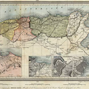
Plan showing the Strait of Constantinople (now the Strait of Bosphorus (Bosporos
LSE4106232 Plan showing the Strait of Constantinople (now the Strait of Bosphorus (Bosporos) - in " Voyage de levant made by the command of the king in the year 1621", edited in 1629 (under the reign of Louis XIII Le Juste) by Unknown Artist, (17th century); Jesuit Library, Cairo, Egypt; (add.info.: Plan showing the Strait of Constantinople (now the Strait of Bosphorus (Bosporos) - in " Voyage de levant made by the command of the king in the year 1621", edited in 1629 (under the reign of Louis XIII Le Juste)); Photo eLeonard de Selva; out of copyright
Media ID 23316580
© Leonard de Selva / Bridgeman Images
Bosphorus Canal Constantinople Maritime Trade Asian Asian Geographical Map Turk
6"x4" (15x10cm) Acrylic Blox
Your photographic print is held in place by magnets and a micro thin sheet of metal covering the back of a 20mm piece of clear acrylic. Your print is held in place with magnets so can easily be replaced if needed.
Streamlined, one sided modern and attractive table top print
Estimated Product Size is 15.2cm x 10.2cm (6" x 4")
These are individually made so all sizes are approximate
Artwork printed orientated as per the preview above, with landscape (horizontal) orientation to match the source image.
FEATURES IN THESE COLLECTIONS
> Africa
> Egypt
> Related Images
> Asia
> Turkey
> Related Images
> Maps and Charts
> Related Images
> Services
> Royal Navy
> Fine Art Finder
> Artists
> Unknown Artist
EDITORS COMMENTS
This print showcases a historical plan depicting the Strait of Constantinople, now known as the Strait of Bosphorus (Bosporos). The artwork originates from the renowned "Voyage de levant made by the command of the king in the year 1621" edited in 1629 during Louis XIII Le Juste's reign. Created by an unknown artist from the 17th century, this engraving is currently housed in Cairo's Jesuit Library. The intricate details and precision of this geographical map offer a glimpse into maritime trade routes and naval activities during that era. It serves as a testament to Asia's significant role in commerce and highlights Turkey's strategic position at the crossroads between Europe and Asia. With its rich history, Constantinople (now Istanbul) was once a bustling hub for trade and cultural exchange. This plan captures its importance as it depicts not only the strait but also canals that were crucial for transportation within this vibrant city. Leonard de Selva skillfully photographed this remarkable piece, preserving its beauty for generations to come. As we admire this image, we are transported back in time to witness an essential chapter in Asian history unfold before our eyes.
MADE IN THE UK
Safe Shipping with 30 Day Money Back Guarantee
FREE PERSONALISATION*
We are proud to offer a range of customisation features including Personalised Captions, Color Filters and Picture Zoom Tools
FREE COLORIZATION SERVICE
You can choose advanced AI Colorization for this picture at no extra charge!
SECURE PAYMENTS
We happily accept a wide range of payment options so you can pay for the things you need in the way that is most convenient for you
* Options may vary by product and licensing agreement. Zoomed Pictures can be adjusted in the Basket.