Acrylic Blox > Arts > Artists > W > Frederick de Wit
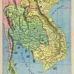
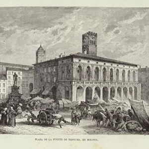
Acrylic Blox : East Indies: Sea and coastal chart extending from Southern India to Japan by the way of


![]()
Mounted Prints from Fine Art Finder
East Indies: Sea and coastal chart extending from Southern India to Japan by the way of
BON111060 East Indies: Sea and coastal chart extending from Southern India to Japan by the way of the East Indian archipelago (coloured engraving) by Wit, Frederick de (1630-1706); Private Collection; Photo eBonhams, London, UK; Dutch, out of copyright
Media ID 23365432
© Bonhams, London, UK / Bridgeman Images
Borneo Cambodia Celebes Galleon Java Malacca New Guinea Siam Sumatra Cape Comorin
8"x6" (20x15cm) Acrylic Blox
Your photographic print is held in place by magnets and a micro thin sheet of metal covering the back of a 20mm piece of clear acrylic. Your print is held in place with magnets so can easily be replaced if needed.
Streamlined, one sided modern and attractive table top print
Estimated Product Size is 20.3cm x 15.2cm (8" x 6")
These are individually made so all sizes are approximate
Artwork printed orientated as per the preview above, with landscape (horizontal) orientation to match the source image.
FEATURES IN THESE COLLECTIONS
> Arts
> Artists
> C
> Cambodian Cambodian
> Arts
> Artists
> W
> Frederick de Wit
> Asia
> Cambodia
> Related Images
> Asia
> India
> Related Images
> Asia
> Japan
> Related Images
> Fine Art Finder
> Artists
> Frederick de Wit
> Fine Art Finder
> Artists
> Spanish School (after)
> Fine Art Finder
> Maps (celestial & Terrestrial)
EDITORS COMMENTS
This stunning print, titled "East Indies: Sea and coastal chart extending from Southern India to Japan by the way of the East Indian archipelago" takes us on a visual journey through the vast expanse of the East Indies. Created by Frederick de Wit in the 17th century, this coloured engraving showcases his exceptional cartography skills. The intricate details of this map transport us back in time, highlighting important landmarks and trade routes that were crucial during that era. From Borneo to Cape Comorin, from Australia to Cambodia, every corner of this region is meticulously depicted with precision and accuracy. The galleon sailing gracefully across these waters adds a touch of adventure to the scene. It reminds us of the explorers who braved unknown territories in search of new lands and resources. The presence of ships like these played a vital role in establishing trade networks between different countries. As we admire this historical masterpiece, it's fascinating to see how much has changed over centuries. The names may have evolved, borders might have shifted, but one thing remains constant –the beauty and diversity found within these lands. This print captures not just an artistic representation but also serves as a reminder of our shared history and interconnectedness as nations. It allows us to appreciate the rich cultural heritage embedded within each country showcased on this map. Overall, this engraving invites us to explore and marvel at the wonders that lie within these once uncharted waters –a true testament to human curiosity and exploration.
MADE IN THE UK
Safe Shipping with 30 Day Money Back Guarantee
FREE PERSONALISATION*
We are proud to offer a range of customisation features including Personalised Captions, Color Filters and Picture Zoom Tools
SECURE PAYMENTS
We happily accept a wide range of payment options so you can pay for the things you need in the way that is most convenient for you
* Options may vary by product and licensing agreement. Zoomed Pictures can be adjusted in the Basket.