Home > Asia > Lebanon > Maps
Black Maps 11

![]()
Wall Art and Photo Gifts from 1x Innovations
Black Maps 11
Emiliano Deificus
Media ID 35042112
FEATURES IN THESE COLLECTIONS
> 1x Gallery
> Maps
> Maps and Charts
> Related Images
VISUAL DESCRIPTION
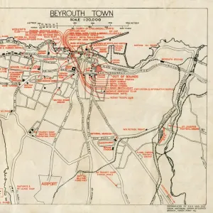
This is a black and white line drawing representing the street map of Beirut, the capital city of Lebanon. The image highlights the dense urban grid with varying street widths, suggesting major thoroughfares as well as smaller roads. To the right side of the image, there appears to be more topographical variation with less dense streets which may indicate hilly or mountainous terrain adjacent to the city area. The bottom of the image provides geographic coordinates for Beirut: 33° 53' 13" N latitude and 35° 30' 47" E longitude, pinpointing its location on Earth's surface.
MADE IN THE UK
Safe Shipping with 30 Day Money Back Guarantee
FREE PERSONALISATION*
We are proud to offer a range of customisation features including Personalised Captions, Color Filters and Picture Zoom Tools
SECURE PAYMENTS
We happily accept a wide range of payment options so you can pay for the things you need in the way that is most convenient for you
* Options may vary by product and licensing agreement. Zoomed Pictures can be adjusted in the Basket.