
Maps Collection
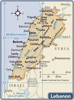
Maps of Lebanon Asia are geographical representations of the Asian country of Lebanon
Choose a picture from our Maps Collection for your Wall Art and Photo Gifts
79 items


All Professionally Made to Order for Quick Shipping
-
Maps Collection
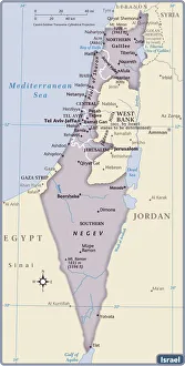
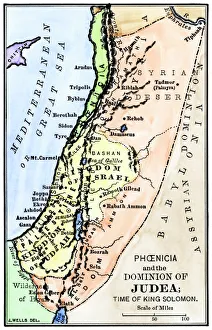
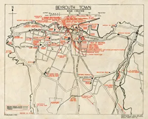
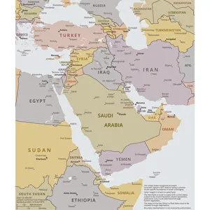
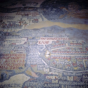
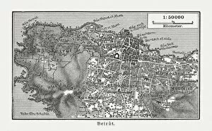
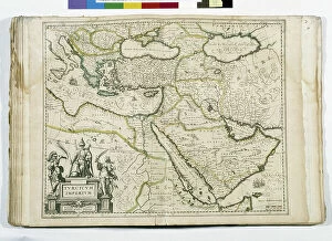
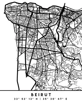
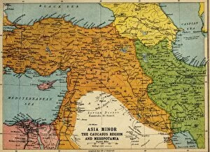
Maps of Lebanon Asia are geographical representations of the Asian country of Lebanon. These maps provide an overview of the region's physical features, such as its mountains, rivers, and deserts. They also show major cities and towns, roads and highways, airports and ports, national parks and monuments and may also include information about population density or other demographic data, and are be used to plan trips or for reference purposes when studying the geography of Lebanon Asia and can help visitors find their way around the country more easily by providing a visual representation of where they are going. It also provide a useful tool for understanding how different parts of this diverse region fit together geographically.
+
Our beautiful pictures are available as Framed Prints, Photos, Wall Art and Photo Gifts
The Maps of Lebanon Asia collection, available on Media Storehouse, is a stunning compilation of vintage and contemporary maps depicting the beautiful country of Lebanon. Our collection features an array of detailed maps that showcase the topography, cities, towns, and landmarks in the region. These maps are perfect for those who want to explore or learn more about this fascinating part of Asia. The Maps of Lebanon Asia collection includes a variety of styles and designs to suit different tastes and preferences. From antique-style prints with intricate details to modern digital renderings with bold colors and fonts, there is something for everyone in this collection. Whether you're looking to decorate your home or office space or simply add some historical context to your studies or research projects, these maps are sure to impress. They make great gifts for history buffs, geography enthusiasts, travelers, students, teachers - anyone who appreciates fine art and culture. The Maps of Lebanon Asia collection from Media Storehouse offers a unique glimpse into one of the most captivating regions in the world.
+
What are Maps of Lebanon Asia art prints?
Maps of Lebanon Asia art prints are high-quality reproductions of vintage and contemporary maps depicting the geography, topography, landmarks, and cities of Lebanon. These art prints showcase the intricate details and artistic styles used in creating these maps, making them not only informative but also aesthetically pleasing. These Maps of Lebanon Asia art prints are perfect for those who love history, geography or simply want to add a unique touch to their home or office decor. They come in various sizes and can be framed according to your preference. Whether you're a collector or just looking for an interesting piece to display on your wall, these Maps of Lebanon Asia art prints offer something for everyone. With their rich colors and detailed designs, they provide a glimpse into the past while adding character to any space.
+
What Maps of Lebanon Asia art prints can I buy from Media Storehouse?
We offer a wide range of Maps of Lebanon Asia art prints that are available for purchase. These maps showcase the beautiful and intricate details of Lebanon's geography, including its mountains, rivers, and cities. Some of the popular options include antique maps from the 19th century as well as modern-day satellite imagery. You can choose from different sizes and formats to suit your preferences, such as framed or unframed prints. The artwork is printed on high-quality paper using state-of-the-art printing technology to ensure vibrant colors and sharp details. Whether you're looking for a unique piece to decorate your home or office or want to gift it to someone who loves history and geography, we have something for everyone. With their vast collection of Maps of Lebanon Asia art prints, you're sure to find one that catches your eye.
+
How do I buy Maps of Lebanon Asia art prints?
To buy maps of Lebanon Asia art prints from Media Storehouse, you can browse our extensive collection of high-quality images online. Simply search for "maps of Lebanon" or "Asia art prints" on our website and select the image that best suits your needs. Once you have chosen your desired print, add it to your cart and proceed to checkout. At checkout, you will be prompted to enter your shipping and payment information. You can choose from a variety of payment options including credit card, PayPal or Apple Pay. We offer a range of sizes and framing options for their prints so you can customize the look to fit your space perfectly. We also offer international shipping so no matter where in the world you are located, they can deliver directly to your doorstep. Buying maps of Lebanon Asia art prints from Media Storehouse is an easy process that allows you to bring beautiful artwork into your home or office with just a few clicks.
+
How much do Maps of Lebanon Asia art prints cost?
We offer a wide range of Maps of Lebanon Asia art prints, which vary in price depending on the size and type of print. The cost for these prints can differ based on the material used to create them, such as canvas or paper. Additionally, the price may also depend on whether you choose a framed or unframed option. The quality of the artwork is exceptional, with each print capturing intricate details that showcase Lebanon's unique geography and culture. These maps are perfect for those who want to decorate their homes or offices with beautiful and meaningful pieces that reflect their love for this region. We provide an excellent selection of Maps of Lebanon Asia art prints at competitive prices. Whether you're looking for a small piece to add some character to your space or a large statement piece that will impress guests, there's something available for everyone's budget and taste.
+
How will my Maps of Lebanon Asia art prints be delivered to me?
We take pride in delivering your Maps of Lebanon Asia art prints with utmost care and efficiency. Once you have placed your order, our team will carefully package your artwork to ensure it arrives at your doorstep in pristine condition. We use high-quality materials for packaging to protect the print from any damage during transit. We work with trusted delivery partners who are experienced in handling delicate items such as art prints. Your Maps of Lebanon Asia art print will be delivered straight to your door, so you don't have to worry about picking it up from a post office or courier depot. Our delivery service is reliable and efficient, ensuring that you receive your artwork within a reasonable timeframe. You can track the progress of your order through our online tracking system, which provides real-time updates on its whereabouts. Rest assured that when you purchase an art print from Media Storehouse, we'll do everything we can to make sure it's delivered safely and securely right to your doorstep.