Home > Animals > Fishes > C > Channel Bass
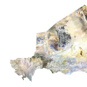
Region of Lower Normandy, France, True Colour Satellite Image

![]()
Wall Art and Photo Gifts from Universal Images Group (UIG)
Region of Lower Normandy, France, True Colour Satellite Image
Satellite view of the departement of Calvados in Lower Normandy, France. Bordered by the English Channel to the north, it includes the famous seaside resort of Deauville. This image was compiled from data acquired by LANDSAT 5 & 7 satellites
Universal Images Group (UIG) manages distribution for many leading specialist agencies worldwide
Media ID 9612621
© Planet Observer
Alsace Bas Rhin Geographical Border Relief Map Satellite View
FEATURES IN THESE COLLECTIONS
> Animals
> Fishes
> C
> Channel Bass
> Europe
> France
> Canton
> Bas Rhin
> Europe
> France
> Canton
> Calvados
> Europe
> France
> Canton
> Rhin
> Universal Images Group (UIG)
> Universal Images Group
> Satellite and Aerial
> Planet Observer 6
EDITORS COMMENTS
This print showcases the breathtaking region of Lower Normandy, France, in all its true colors. The satellite view of the departement of Calvados reveals a stunning landscape bordered by the majestic English Channel to the north. One cannot help but be enchanted by this image that captures both the natural beauty and man-made wonders of this remarkable area. The famous seaside resort of Deauville is prominently featured, adding an element of allure and charm to the scene. As we explore every inch of this photograph, it becomes evident that it was compiled from data acquired by LANDSAT 5 & 7 satellites, ensuring accuracy and precision. The topography on display highlights not only the geographical borders but also provides a relief map showcasing the diverse physical geography found in this region. It is fascinating to observe how nature has sculpted these lands over time. With no people present in this image, our attention is solely focused on admiring Mother Nature's masterpiece. The vibrant colors bring life to every corner captured by this vertical shot taken from above. As we delve into cartography and study Europe's landscapes, photographs like these become invaluable tools for understanding our world better. This particular print offers a glimpse into Lower Normandy's unique characteristics while leaving us yearning for more adventures in France's Alsace region.
MADE IN THE UK
Safe Shipping with 30 Day Money Back Guarantee
FREE PERSONALISATION*
We are proud to offer a range of customisation features including Personalised Captions, Color Filters and Picture Zoom Tools
SECURE PAYMENTS
We happily accept a wide range of payment options so you can pay for the things you need in the way that is most convenient for you
* Options may vary by product and licensing agreement. Zoomed Pictures can be adjusted in the Basket.