Home > Europe > France > Canton > Bas Rhin
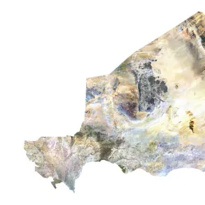
Hungary, Relief Map

![]()
Wall Art and Photo Gifts from Universal Images Group (UIG)
Hungary, Relief Map
Relief map of Hungary. This map was processed from elevation data
Universal Images Group (UIG) manages distribution for many leading specialist agencies worldwide
Media ID 9608829
© Planet Observer
Alsace Bas Rhin Geographical Border Relief Map Satellite View
FEATURES IN THESE COLLECTIONS
> Aerial Photography
> Hungary
> Europe
> France
> Canton
> Bas Rhin
> Europe
> France
> Canton
> Rhin
> Universal Images Group (UIG)
> Universal Images Group
> Satellite and Aerial
> Planet Observer 6
EDITORS COMMENTS
This print showcases the intricate relief map of Hungary, a stunning representation of its topography and physical geography. Processed from elevation data, this meticulously crafted map offers a bird's-eye view of Hungary's diverse landscape. The vibrant colors and detailed contours bring to life the country's geographical borders, allowing viewers to appreciate its natural beauty. The vertical composition of this photograph adds depth and perspective, immersing us in the vastness of Hungary's terrain. With no people present in the frame, our attention is solely focused on the intricacies of this relief map. It serves as a reminder that beyond bustling cities and urban landscapes lies an awe-inspiring world shaped by nature itself. As we explore every inch of this image, we are transported to different regions within Hungary – from rolling hills to majestic mountains, from serene lakes to winding rivers. This satellite view captures it all with remarkable precision. Created by skilled cartographers at Universal Images Group (UIG), this print is not just a visual masterpiece but also an educational tool that allows us to understand Hungary's landforms better. Whether you have an interest in geography or simply admire breathtaking imagery, this piece will undoubtedly captivate your imagination and transport you into the heartland of Europe – where history meets natural wonders.
MADE IN THE UK
Safe Shipping with 30 Day Money Back Guarantee
FREE PERSONALISATION*
We are proud to offer a range of customisation features including Personalised Captions, Color Filters and Picture Zoom Tools
SECURE PAYMENTS
We happily accept a wide range of payment options so you can pay for the things you need in the way that is most convenient for you
* Options may vary by product and licensing agreement. Zoomed Pictures can be adjusted in the Basket.