Home > Europe > France > Canton > Bas Rhin
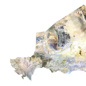
Djibouti, Relief Map

![]()
Wall Art and Photo Gifts from Universal Images Group (UIG)
Djibouti, Relief Map
Relief map of Djibouti. This map was processed from elevation data
Universal Images Group (UIG) manages distribution for many leading specialist agencies worldwide
Media ID 9612605
© Planet Observer
Alsace Bas Rhin Geographical Border Relief Map Satellite View
FEATURES IN THESE COLLECTIONS
> Europe
> France
> Canton
> Bas Rhin
> Europe
> France
> Canton
> Rhin
> Universal Images Group (UIG)
> Universal Images Group
> Satellite and Aerial
> Planet Observer 6
EDITORS COMMENTS
This print showcases the stunning relief map of Djibouti, a small yet mesmerizing country located in East Africa. The intricate details and precision of this map were meticulously processed from elevation data, resulting in a visually striking representation of Djibouti's topography. Every contour and ridge is beautifully captured, allowing viewers to appreciate the diverse landscapes that make up this fascinating region. The vibrant colors used in this image enhance its appeal, bringing life to the geographical borders and highlighting the natural beauty of Djibouti. With no people present in the photograph, one can fully immerse themselves in studying every inch of this relief map without any distractions. Taken from a satellite view perspective, this photograph offers a unique opportunity to explore Djibouti's physical geography from an aerial standpoint. From towering mountains to vast plains and winding rivers, each element contributes to the rich tapestry that defines this remarkable nation. Whether you are an enthusiast of cartography or simply intrigued by different landscapes around the world, this print will undoubtedly captivate your attention. Its vertical composition adds depth and dimensionality to the image while providing an alternative viewpoint rarely seen on traditional maps
MADE IN THE UK
Safe Shipping with 30 Day Money Back Guarantee
FREE PERSONALISATION*
We are proud to offer a range of customisation features including Personalised Captions, Color Filters and Picture Zoom Tools
SECURE PAYMENTS
We happily accept a wide range of payment options so you can pay for the things you need in the way that is most convenient for you
* Options may vary by product and licensing agreement. Zoomed Pictures can be adjusted in the Basket.