Home > Europe > France > Canton > Vendee
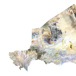
Departement of Loire-Atlantique, France, True Colour Satellite Image

![]()
Wall Art and Photo Gifts from Universal Images Group (UIG)
Departement of Loire-Atlantique, France, True Colour Satellite Image
Satellite view of the departement of Vendee in Pays-de-la-Loire, France. Bordered by the Atlantic ocean to the west, it includes Ile d Yeu and Noirmoutier islands. This image was compiled from data acquired by LANDSAT 5 & 7 satellites
Universal Images Group (UIG) manages distribution for many leading specialist agencies worldwide
Media ID 9618259
© Planet Observer
Alsace Bas Rhin Geographical Border Relief Map Satellite View
FEATURES IN THESE COLLECTIONS
> Europe
> France
> Canton
> Bas Rhin
> Europe
> France
> Canton
> Loire
> Europe
> France
> Canton
> Rhin
> Europe
> France
> Canton
> Vendee
> Universal Images Group (UIG)
> Universal Images Group
> Satellite and Aerial
> Planet Observer 6
EDITORS COMMENTS
This print showcases the stunning beauty of the Departement of Loire-Atlantique in France. Taken from a true color satellite view, this image provides a bird's eye perspective of the picturesque Vendee region in Pays-de-la-Loire. Bordered by the vast Atlantic Ocean to its west, this area encompasses not only breathtaking landscapes but also includes the enchanting Ile d Yeu and Noirmoutier islands. Compiled from data acquired by LANDSAT 5 & 7 satellites, this print offers an intricate depiction of both topography and physical geography. The vibrant colors and detailed relief map highlight every contour and feature of this mesmerizing region. With no people present in the frame, it allows viewers to immerse themselves fully into nature's wonders. The geographical border between land and sea is beautifully captured in this photograph, showcasing Europe's diverse landscape at its finest. Its vertical composition adds depth to the image while emphasizing its cartographic significance. As part of Universal Images Group (UIG)'s collection, this print serves as a testament to their dedication towards preserving remarkable moments through photography
MADE IN THE UK
Safe Shipping with 30 Day Money Back Guarantee
FREE PERSONALISATION*
We are proud to offer a range of customisation features including Personalised Captions, Color Filters and Picture Zoom Tools
SECURE PAYMENTS
We happily accept a wide range of payment options so you can pay for the things you need in the way that is most convenient for you
* Options may vary by product and licensing agreement. Zoomed Pictures can be adjusted in the Basket.