Home > Europe > France > Canton > Bas Rhin
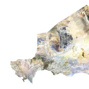
Central African Republic, Relief Map

![]()
Wall Art and Photo Gifts from Universal Images Group (UIG)
Central African Republic, Relief Map
Relief map of Central African Republic. This map was processed from elevation data
Universal Images Group (UIG) manages distribution for many leading specialist agencies worldwide
Media ID 9618223
© Planet Observer
Alsace Bas Rhin Geographical Border Relief Map Satellite View
FEATURES IN THESE COLLECTIONS
> Africa
> Central African Republic
> Maps
> Europe
> France
> Canton
> Bas Rhin
> Europe
> France
> Canton
> Rhin
> Universal Images Group (UIG)
> Universal Images Group
> Satellite and Aerial
> Planet Observer 6
EDITORS COMMENTS
This stunning print showcases the intricate and detailed relief map of the Central African Republic, a landlocked country in Central Africa. The map, processed from elevation data, beautifully captures the topography of this diverse nation. From its lush rainforests to rolling hills and expansive savannahs, every contour is meticulously depicted. The vibrant colors used in this image bring the map to life, highlighting geographical borders and providing a visual representation of the country's physical geography. With no people present in the photograph, it allows viewers to focus solely on appreciating the natural beauty and complexity of this region. Taken from a satellite view perspective, this aerial shot provides an unparalleled overview of Central African Republic's terrain. It offers a unique opportunity for exploration and understanding of its diverse landscapes. Displayed against a backdrop reminiscent of Alsace in France, this print seamlessly combines elements from different parts of Europe with an emphasis on cartography. It serves as both an informative tool for geographers and enthusiasts alike while also doubling as a captivating piece of art that would enhance any space
MADE IN THE UK
Safe Shipping with 30 Day Money Back Guarantee
FREE PERSONALISATION*
We are proud to offer a range of customisation features including Personalised Captions, Color Filters and Picture Zoom Tools
SECURE PAYMENTS
We happily accept a wide range of payment options so you can pay for the things you need in the way that is most convenient for you
* Options may vary by product and licensing agreement. Zoomed Pictures can be adjusted in the Basket.