Home > Europe > France > Canton > Bas Rhin
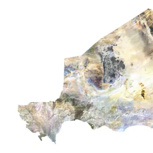
Photographic Print : Burkina Faso, Relief Map


![]()
Photo Prints from Universal Images Group (UIG)
Burkina Faso, Relief Map
Relief map of Burkina Faso. This map was processed from elevation data
Universal Images Group (UIG) manages distribution for many leading specialist agencies worldwide
Media ID 9618145
© Planet Observer
Alsace Bas Rhin Geographical Border Relief Map Satellite View
10"x8" (25x20cm) Photo Print
Discover the beauty and complexity of Burkina Faso with our exquisite Media Storehouse Photographic Print of a relief map from Universal Images Group (UIG). This stunning representation of the West African country's topography offers a unique perspective, processed from accurate elevation data. Bring the intricacies of Burkina Faso's terrain into your home or office as a captivating conversation starter or an essential addition to your study or classroom. Experience the power of visual storytelling with our high-quality, museum-grade prints, designed to last a lifetime.
Printed on archival quality paper for unrivalled stable artwork permanence and brilliant colour reproduction with accurate colour rendition and smooth tones. Printed on professional 234gsm Fujifilm Crystal Archive DP II paper. 10x8 for landscape images, 8x10 for portrait images.
Our Photo Prints are in a large range of sizes and are printed on Archival Quality Paper for excellent colour reproduction and longevity. They are ideal for framing (our Framed Prints use these) at a reasonable cost. Alternatives include cheaper Poster Prints and higher quality Fine Art Paper, the choice of which is largely dependant on your budget.
Estimated Image Size (if not cropped) is 25.4cm x 18cm (10" x 7.1")
Estimated Product Size is 25.4cm x 20.3cm (10" x 8")
These are individually made so all sizes are approximate
Artwork printed orientated as per the preview above, with landscape (horizontal) orientation to match the source image.
FEATURES IN THESE COLLECTIONS
> Africa
> Burkina Faso
> Maps
> Africa
> Burkina Faso
> Related Images
> Europe
> France
> Canton
> Bas Rhin
> Europe
> France
> Canton
> Rhin
> Universal Images Group (UIG)
> Universal Images Group
> Satellite and Aerial
> Planet Observer 6
EDITORS COMMENTS
This stunning print captures the intricate details of Burkina Faso's relief map, showcasing the country's diverse topography. Processed from elevation data, this map provides a fascinating insight into Burkina Faso's physical geography. The varying shades and contours beautifully illustrate the country's mountain ranges, plateaus, and plains. The vibrant colors used in this image enhance its visual appeal while maintaining accuracy in representing geographical borders. With no people present in the frame, the focus remains solely on Burkina Faso's natural landscape. This aerial perspective offers a unique satellite view that allows viewers to appreciate the vastness and complexity of this West African nation. Displayed against a backdrop of Alsace, France, where Universal Images Group (UIG) captured this photograph, it serves as a reminder of how our world is interconnected across continents. The vertical composition adds depth to the image and emphasizes both Burkina Faso's landforms and its position within Europe. This piece is not only visually striking but also holds educational value for cartographers or those interested in geography. It invites exploration and sparks curiosity about Burkina Faso’s rich terrain and environmental diversity
MADE IN THE UK
Safe Shipping with 30 Day Money Back Guarantee
FREE PERSONALISATION*
We are proud to offer a range of customisation features including Personalised Captions, Color Filters and Picture Zoom Tools
SECURE PAYMENTS
We happily accept a wide range of payment options so you can pay for the things you need in the way that is most convenient for you
* Options may vary by product and licensing agreement. Zoomed Pictures can be adjusted in the Basket.