Home > Africa > Malawi > Maps
Canvas Print : Mozambique, Relief Map With Border and Mask


![]()
Canvas Prints from Universal Images Group (UIG)
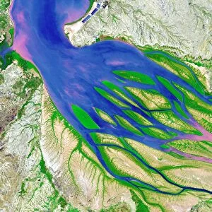
Mozambique, Relief Map With Border and Mask
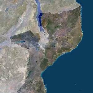
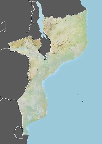
Relief map of Mozambique (with border and mask). This image was compiled from data acquired by landsat 5 & 7 satellites combined with elevation data
Universal Images Group (UIG) manages distribution for many leading specialist agencies worldwide
Media ID 9613095
© Planet Observer/UIG
Africa Coastline Indian Ocean Lake Malawi Relief Map Shore Maputo Mozambique Satellite View
20"x16" (50x40cm) Canvas Print
Discover the beauty and complexity of Mozambique's geography with our stunning Canvas Print from Media Storehouse, featuring a relief map image from Universal Images Group (UIG). This captivating representation of Mozambique's terrain is meticulously compiled from data acquired by Landsat 5 & 7 satellites, enhanced with elevation data. Transform your space with this intriguing and educational piece, perfect for world travelers, geography enthusiasts, or anyone seeking a unique conversation starter. Experience the detail and depth of the map in vivid colors and textures, expertly printed on high-quality canvas for a museum-grade finish. Add a touch of adventure and exploration to your home or office decor.
Ready to hang Premium Gloss Canvas Print. Our archival quality canvas prints are made from Polyester and Cotton mix and stretched over a 1.25" (32mm) kiln dried knot free wood stretcher bar. Packaged in a plastic bag and secured to a cardboard insert for transit.
Canvas Prints add colour, depth and texture to any space. Professionally Stretched Canvas over a hidden Wooden Box Frame and Ready to Hang
Estimated Product Size is 40.6cm x 50.8cm (16" x 20")
These are individually made so all sizes are approximate
Artwork printed orientated as per the preview above, with portrait (vertical) orientation to match the source image.
FEATURES IN THESE COLLECTIONS
> Africa
> Malawi
> Lakes
> Related Images
> Africa
> Malawi
> Related Images
> Africa
> Mozambique
> Lakes
> Related Images
> Africa
> Mozambique
> Maps
> Africa
> Mozambique
> Maputo
> Africa
> Mozambique
> Related Images
> Universal Images Group (UIG)
> Universal Images Group
> Satellite and Aerial
> Planet Observer 4
EDITORS COMMENTS
This print showcases the stunning relief map of Mozambique, a country nestled on the southeastern coast of Africa. With intricate details and vibrant colors, this image offers a unique perspective on the physical geography of Mozambique. Compiled from data acquired by Landsat 5 & 7 satellites combined with elevation data, it presents an accurate representation of the country's topography. The border and mask surrounding the relief map add an artistic touch to this photograph, enhancing its visual appeal. The vertical composition allows viewers to appreciate every aspect of Mozambique's landscape, from its expansive coastline along the Indian Ocean to its inland features such as Lake Malawi. As we gaze upon this remarkable satellite view captured by Universal Images Group (UIG), we are reminded of Mozambique's natural beauty and diverse terrain. This print serves as both a cartographic masterpiece and a testament to the wonders found in our world. With no people present in this image, it allows us to focus solely on appreciating Mozambique's geographical marvels. Whether you have personal ties to this African nation or simply admire breathtaking landscapes, this print is sure to captivate your imagination
MADE IN THE UK
Safe Shipping with 30 Day Money Back Guarantee
FREE PERSONALISATION*
We are proud to offer a range of customisation features including Personalised Captions, Color Filters and Picture Zoom Tools
SECURE PAYMENTS
We happily accept a wide range of payment options so you can pay for the things you need in the way that is most convenient for you
* Options may vary by product and licensing agreement. Zoomed Pictures can be adjusted in the Basket.