Home > Africa > Liberia > Maps
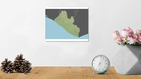
Photographic Print : Liberia, Relief Map With Border and Mask


![]()
Photo Prints from Universal Images Group (UIG)
Liberia, Relief Map With Border and Mask
Relief map of Liberia (with border and mask). This image was compiled from data acquired by landsat 5 & 7 satellites combined with elevation data
Universal Images Group (UIG) manages distribution for many leading specialist agencies worldwide
Media ID 9619101
© Planet Observer/UIG
Africa Coastline Liberia Relief Map Shore Monrovia Satellite View
10"x8" (25x20cm) Photo Print
Discover the beauty and complexity of Liberia with our exquisite Media Storehouse Photographic Print of a Relief Map, expertly crafted from data acquired by Landsat 5 and 7 satellites. This stunning representation of Liberia's topography is enhanced with clear borders and a traditional Liberian mask design. Bring the intricacies of this West African country into your home or office with this unique and educational piece. Order now and elevate your space with the captivating allure of the Media Storehouse Photographic Prints collection.
Printed on archival quality paper for unrivalled stable artwork permanence and brilliant colour reproduction with accurate colour rendition and smooth tones. Printed on professional 234gsm Fujifilm Crystal Archive DP II paper. 10x8 for landscape images, 8x10 for portrait images.
Our Photo Prints are in a large range of sizes and are printed on Archival Quality Paper for excellent colour reproduction and longevity. They are ideal for framing (our Framed Prints use these) at a reasonable cost. Alternatives include cheaper Poster Prints and higher quality Fine Art Paper, the choice of which is largely dependant on your budget.
Estimated Image Size (if not cropped) is 25.4cm x 18cm (10" x 7.1")
Estimated Product Size is 25.4cm x 20.3cm (10" x 8")
These are individually made so all sizes are approximate
Artwork printed orientated as per the preview above, with landscape (horizontal) orientation to match the source image.
FEATURES IN THESE COLLECTIONS
> Africa
> Liberia
> Related Images
> Universal Images Group (UIG)
> Universal Images Group
> Satellite and Aerial
> Planet Observer 4
EDITORS COMMENTS
This print showcases the stunning relief map of Liberia, adorned with a border and mask. Created using data acquired by Landsat 5 & 7 satellites, combined with elevation data, this image offers a unique perspective on the physical geography of Liberia. The intricate details captured in this photograph allow viewers to explore the country's diverse topography, from its lush shorelines to its majestic mountain ranges. The vibrant colors and precise cartography make this print an ideal addition for any geography enthusiast or lover of African landscapes. With no people present in the frame, the focus remains solely on Liberia's natural beauty and geographical features. This horizontal composition allows for easy display in various settings, whether it be at home or within educational institutions. As one gazes upon this satellite view of Liberia, they are transported into a world where land meets sea and mountains touch sky. The coastline stretches out gracefully along the edges while valleys and peaks create mesmerizing patterns across the landscape. It is as if nature itself has become an artist, painting a masterpiece that captivates all who lay eyes upon it. With Monrovia serving as its capital city, Liberia holds rich history and cultural significance within Africa. This print not only serves as a visual delight but also acts as an educational tool for those seeking to deepen their understanding of this remarkable nation's physical attributes. Let your imagination soar as you embark on a virtual journey through Liberia's breathtaking relief map displayed in all its glory through this exquisite photograph from Universal Images Group (U
MADE IN THE UK
Safe Shipping with 30 Day Money Back Guarantee
FREE PERSONALISATION*
We are proud to offer a range of customisation features including Personalised Captions, Color Filters and Picture Zoom Tools
SECURE PAYMENTS
We happily accept a wide range of payment options so you can pay for the things you need in the way that is most convenient for you
* Options may vary by product and licensing agreement. Zoomed Pictures can be adjusted in the Basket.