Home > Aerial Photography > Africa
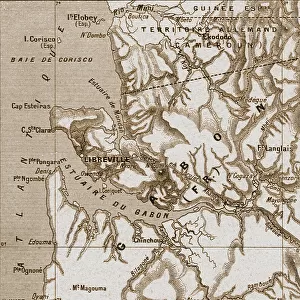
Equatorial Guinea, Relief Map With Border and Mask

![]()
Wall Art and Photo Gifts from Universal Images Group (UIG)
Equatorial Guinea, Relief Map With Border and Mask
Relief map of Equatorial Guinea (with border and mask). This image was compiled from data acquired by landsat 5 & 7 satellites combined with elevation data
Universal Images Group (UIG) manages distribution for many leading specialist agencies worldwide
Media ID 9613147
© Planet Observer/UIG
Africa Coastline Equatorial Guinea Relief Map Shore Satellite View
FEATURES IN THESE COLLECTIONS
> Africa
> Equatorial Guinea
> Maps
> Universal Images Group (UIG)
> Universal Images Group
> Satellite and Aerial
> Planet Observer 4
EDITORS COMMENTS
This print showcases the stunning beauty of Equatorial Guinea, a country nestled on the west coast of Central Africa. The image presents a relief map that has been meticulously created using data acquired by Landsat 5 & 7 satellites, combined with elevation information. With its vibrant colors and intricate details, this map offers an immersive experience into the physical geography of Equatorial Guinea. The photograph captures the diverse topography of this enchanting nation, from its pristine shorelines to its rugged mountain ranges. The border and mask surrounding the relief map add an artistic touch, enhancing its visual appeal. This horizontal composition allows viewers to fully appreciate the vastness and complexity of Equatorial Guinea's landscape. Notably absent are any human figures in this image, emphasizing nature's dominance in shaping this land. The absence also invites viewers to imagine themselves exploring these unspoiled terrains firsthand. Equatorial Guinea is home to two major cities: Bata and Malabo. While not explicitly mentioned in the captioned description provided by Universal Images Group (UIG), it is likely that these urban centers are represented within this relief map as well. Overall, this print serves as both a work of art and an educational tool for those interested in cartography or studying physical geography. It provides a unique satellite view that reveals Equatorial Guinea's natural wonders while inviting us to embark on our own imaginary journey through its breathtaking landscapes.
MADE IN THE UK
Safe Shipping with 30 Day Money Back Guarantee
FREE PERSONALISATION*
We are proud to offer a range of customisation features including Personalised Captions, Color Filters and Picture Zoom Tools
SECURE PAYMENTS
We happily accept a wide range of payment options so you can pay for the things you need in the way that is most convenient for you
* Options may vary by product and licensing agreement. Zoomed Pictures can be adjusted in the Basket.