Home > Africa > Democratic Republic of the Congo > Lakes > Lake Tanganyika
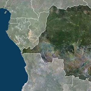
Democratic Republic of Congo, Relief Map With Border and Mask
![]()

Wall Art and Photo Gifts from Universal Images Group (UIG)
Democratic Republic of Congo, Relief Map With Border and Mask
Relief map of Democratic Republic of Congo (with border and mask). This image was compiled from data acquired by landsat 5 & 7 satellites combined with elevation data
Universal Images Group (UIG) manages distribution for many leading specialist agencies worldwide
Media ID 9613233
© Planet Observer/UIG
Africa Coastline Lake Tanganyika Relief Map Shore Democratic Republic Of Congo Goma Kinshasa Satellite View
FEATURES IN THESE COLLECTIONS
> Africa
> Democratic Republic of the Congo
> Lakes
> Lake Tanganyika
> Africa
> Republic of the Congo
> Lakes
> Related Images
> Africa
> Republic of the Congo
> Maps
> Universal Images Group (UIG)
> Universal Images Group
> Satellite and Aerial
> Planet Observer 4
EDITORS COMMENTS
This print showcases the stunning Relief Map of the Democratic Republic of Congo, adorned with a border and mask. Created using data acquired by Landsat 5 & 7 satellites, combined with elevation data, this image offers a unique perspective on the physical geography of this African nation. The horizontal composition allows for an immersive experience as one explores the intricate details of its shorelines, topography, and coastline. The vibrant colors used in this map bring to life the diverse landscapes that make up the Democratic Republic of Congo. From the vast Lake Tanganyika to bustling Kinshasa and Goma, each region is beautifully represented in this cartographic masterpiece. This satellite view provides an unparalleled opportunity to appreciate the country's natural beauty without any human presence. Beyond being visually striking, this print serves as both an educational tool and a work of art. It invites viewers to delve into the rich history and cultural heritage embedded within these lands. Whether you are a geography enthusiast or simply captivated by Africa's allure, this image will transport you to distant corners of one of Africa's most fascinating countries
MADE IN THE UK
Safe Shipping with 30 Day Money Back Guarantee
FREE PERSONALISATION*
We are proud to offer a range of customisation features including Personalised Captions, Color Filters and Picture Zoom Tools
SECURE PAYMENTS
We happily accept a wide range of payment options so you can pay for the things you need in the way that is most convenient for you
* Options may vary by product and licensing agreement. Zoomed Pictures can be adjusted in the Basket.


