Home > Africa > Burundi > Lakes > Lake Tanganyika
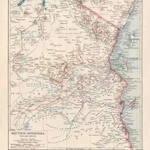
Burundi, Relief Map With Border and Mask

![]()
Wall Art and Photo Gifts from Universal Images Group (UIG)
Burundi, Relief Map With Border and Mask
Relief map of Burundi (with border and mask). This image was compiled from data acquired by landsat 5 & 7 satellites combined with elevation data
Universal Images Group (UIG) manages distribution for many leading specialist agencies worldwide
Media ID 9613455
© Planet Observer/UIG
Africa Burundi Great Lakes Great Rift Valley Lake Tanganyika Relief Map Satellite View
FEATURES IN THESE COLLECTIONS
> Africa
> Burundi
> Bujumbura
> Africa
> Burundi
> Lakes
> Lake Tanganyika
> Universal Images Group (UIG)
> Universal Images Group
> Satellite and Aerial
> Planet Observer 4
EDITORS COMMENTS
This print showcases the stunning relief map of Burundi, a small landlocked country in East Africa. Compiled from data acquired by Landsat 5 & 7 satellites combined with elevation data, this image offers a unique perspective on the topography and physical geography of Burundi. The intricate details captured in this photograph highlight the diverse landscape that characterizes the region. From its majestic mountains to its vast plains, every contour is beautifully depicted, providing viewers with an immersive experience into Burundi's natural beauty. The border and mask surrounding the relief map add an artistic touch to this already mesmerizing image. The vibrant colors used further enhance the visual appeal, making it a true work of art. Notably, one can observe the presence of Lake Tanganyika - one of Africa's Great Lakes - which borders Burundi and adds to its scenic charm. The Great Rift Valley also makes its mark on this relief map, showcasing nature's remarkable geological formations. With no people visible in this photograph, it allows us to solely focus on appreciating Mother Nature's wonders at play. This aerial view provides a bird's-eye perspective that would otherwise be impossible to witness firsthand. Whether you are passionate about cartography or simply fascinated by African landscapes, this print is sure to captivate your imagination and transport you straight into the heart of Burundi's breathtaking scenery.
MADE IN THE UK
Safe Shipping with 30 Day Money Back Guarantee
FREE PERSONALISATION*
We are proud to offer a range of customisation features including Personalised Captions, Color Filters and Picture Zoom Tools
SECURE PAYMENTS
We happily accept a wide range of payment options so you can pay for the things you need in the way that is most convenient for you
* Options may vary by product and licensing agreement. Zoomed Pictures can be adjusted in the Basket.