Home > Africa > Burkina Faso > Maps
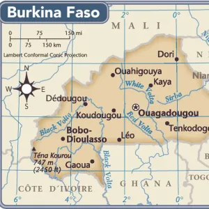
Photographic Print : Burkina Faso, Relief Map With Border and Mask


![]()
Photo Prints from Universal Images Group (UIG)
Burkina Faso, Relief Map With Border and Mask
Relief map of Burkina Faso (with border and mask). This image was compiled from data acquired by landsat 5 & 7 satellites combined with elevation data
Universal Images Group (UIG) manages distribution for many leading specialist agencies worldwide
Media ID 9619271
© Planet Observer/UIG
Africa Relief Map Burkina Faso Satellite View
10"x8" (25x20cm) Photo Print
Discover the beauty and complexity of Burkina Faso with our stunning Media Storehouse Photographic Print of a relief map from Universal Images Group (UIG). This captivating image provides a unique perspective, combining detailed border information with an intricately designed mask overlay. Meticulously compiled from data acquired by Landsat 5 & 7 satellites and elevation data, this print offers an accurate and visually appealing representation of Burkina Faso's diverse topography. Bring a piece of the world into your home or office with this intriguing and informative piece of wall art.
Printed on archival quality paper for unrivalled stable artwork permanence and brilliant colour reproduction with accurate colour rendition and smooth tones. Printed on professional 234gsm Fujifilm Crystal Archive DP II paper. 10x8 for landscape images, 8x10 for portrait images.
Our Photo Prints are in a large range of sizes and are printed on Archival Quality Paper for excellent colour reproduction and longevity. They are ideal for framing (our Framed Prints use these) at a reasonable cost. Alternatives include cheaper Poster Prints and higher quality Fine Art Paper, the choice of which is largely dependant on your budget.
Estimated Image Size (if not cropped) is 25.4cm x 18cm (10" x 7.1")
Estimated Product Size is 25.4cm x 20.3cm (10" x 8")
These are individually made so all sizes are approximate
Artwork printed orientated as per the preview above, with landscape (horizontal) orientation to match the source image.
FEATURES IN THESE COLLECTIONS
> Africa
> Burkina Faso
> Maps
> Africa
> Burkina Faso
> Related Images
> Universal Images Group (UIG)
> Universal Images Group
> Satellite and Aerial
> Planet Observer 4
EDITORS COMMENTS
This print showcases the stunning relief map of Burkina Faso, adorned with a border and an intriguing mask. The image is a result of combining data acquired by Landsat 5 & 7 satellites along with elevation data, offering us a unique perspective on the topography of this West African country. The vibrant colors and intricate details in this horizontal photograph bring to life the physical geography of Burkina Faso. From its capital city Ouagadougou to its vast outdoors, every corner seems to be meticulously captured in this mesmerizing shot. The absence of people allows us to focus solely on the natural beauty and diverse landscapes that define Burkina Faso. Cartography enthusiasts will undoubtedly appreciate this remarkable piece as it perfectly encapsulates the essence of satellite view photography. It serves as both an educational tool for studying the geographical features and as a visual treat for those who admire Africa's rich tapestry. As we gaze upon this exceptional print from Universal Images Group (UIG), we are transported into an immersive world where technology meets artistry. This image not only celebrates Burkina Faso's distinctive terrain but also highlights how advancements in satellite imagery have revolutionized our understanding and appreciation for different regions across the globe
MADE IN THE UK
Safe Shipping with 30 Day Money Back Guarantee
FREE PERSONALISATION*
We are proud to offer a range of customisation features including Personalised Captions, Color Filters and Picture Zoom Tools
SECURE PAYMENTS
We happily accept a wide range of payment options so you can pay for the things you need in the way that is most convenient for you
* Options may vary by product and licensing agreement. Zoomed Pictures can be adjusted in the Basket.