Home > Europe > Italy > Heritage Sites > Ferrara, City of the Renaissance
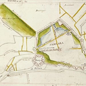
Plan of Ferrara, 1598

![]()
Wall Art and Photo Gifts from Universal Images Group (UIG)
Plan of Ferrara, 1598
Cartography, Italy, 16th century. Plan of Ferrara, 1598
Universal Images Group (UIG) manages distribution for many leading specialist agencies worldwide
Media ID 9501447
© DEA / A. DE GREGORIO
16th Century City Ferrara Fortified Wall Plan Western Script
FEATURES IN THESE COLLECTIONS
> Architecture
> Country
> Italy
> Related Images
> Europe
> Italy
> Emilia-Romagna
> Ferrara
> Europe
> Italy
> Heritage Sites
> Ferrara, City of the Renaissance
> Europe
> Italy
> Sculptures
> Universal Images Group (UIG)
> Art
> Painting, Sculpture & Prints
> Cartography
EDITORS COMMENTS
This print showcases a remarkable piece of cartography from the 16th century - the Plan of Ferrara, 1598. With its intricate details and historical significance, this map transports us back in time to explore the city's architectural marvels and rich history. The plan depicts Ferrara, an enchanting Italian city renowned for its splendid Renaissance architecture. The full-length view allows us to appreciate every aspect of this meticulously crafted map, capturing the essence of Ferrara during that era. The horizontal composition emphasizes the sprawling layout of the city, highlighting its grandeur and scale. As we delve into this studio-shot print, we are captivated by the precise representation of Ferrara's fortified walls. These formidable structures were once crucial in defending against external threats while also serving as a testament to the city's power and prestige. The absence of people in this image adds an air of mystery, allowing our imagination to wander through these ancient streets. The artistry displayed in this illustration is truly remarkable; it seamlessly combines elements of physical geography with Western script typography. This fusion creates a visually stunning piece that not only serves as a navigational tool but also stands as a work of art itself. With its historical significance and artistic brilliance, this print offers an intriguing glimpse into Ferrara's past. It is undoubtedly a valuable addition for enthusiasts interested in cartography, architecture or simply those who appreciate exquisite craftsmanship from centuries gone by.
MADE IN THE UK
Safe Shipping with 30 Day Money Back Guarantee
FREE PERSONALISATION*
We are proud to offer a range of customisation features including Personalised Captions, Color Filters and Picture Zoom Tools
SECURE PAYMENTS
We happily accept a wide range of payment options so you can pay for the things you need in the way that is most convenient for you
* Options may vary by product and licensing agreement. Zoomed Pictures can be adjusted in the Basket.