Home > Arts > Landscape paintings > Waterfall and river artworks > River artworks
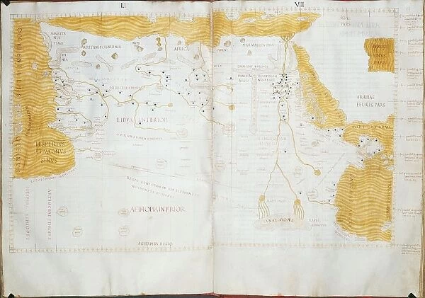
Map of Northern Africa, Ptolemys Moon Mountains are indicated as source of Nile River
![]()

Wall Art and Photo Gifts from Universal Images Group (UIG)
Map of Northern Africa, Ptolemys Moon Mountains are indicated as source of Nile River
Cartography, 15th century. Map of Northern Africa. Ptolemys Moon Mountains are indicated as the sources of Nile River
Universal Images Group (UIG) manages distribution for many leading specialist agencies worldwide
Media ID 9571595
© DEA PICTURE LIBRARY
15th Century Egypt Geography Guidance Libya Nile River River
FEATURES IN THESE COLLECTIONS
> Arts
> Landscape paintings
> Waterfall and river artworks
> River artworks
> Universal Images Group (UIG)
> Art
> Painting, Sculpture & Prints
> Cartography
EDITORS COMMENTS
This 15th-century map of Northern Africa, sourced from Universal Images Group (UIG), offers a fascinating glimpse into the ancient world of cartography. The intricate details and artistic finesse showcased in this print are truly remarkable. Depicting the vast expanse of Egypt and its iconic Nile River, this historical gem highlights an intriguing aspect - Ptolemy's Moon Mountains as the sources of this mighty river. The map takes us on a visual journey through time, providing invaluable insights into the geography and history of this region. It serves as a testament to humanity's relentless pursuit of knowledge and understanding even centuries ago. With its horizontal orientation, it invites viewers to immerse themselves in every minute detail meticulously etched onto its surface. As we gaze upon this studio-shot masterpiece, we can't help but marvel at how our ancestors navigated these lands without modern technology or satellite imagery. This map becomes more than just lines on paper; it becomes a gateway to exploration and discovery. Through studying maps like these, we gain not only geographical guidance but also a deeper appreciation for the rich tapestry that is human history. Let us cherish such treasures that connect us with our past while igniting curiosity about what lies beyond those Moon Mountains - reminding us that there is always more to explore both within ourselves and in the world around us.
MADE IN THE UK
Safe Shipping with 30 Day Money Back Guarantee
FREE PERSONALISATION*
We are proud to offer a range of customisation features including Personalised Captions, Color Filters and Picture Zoom Tools
SECURE PAYMENTS
We happily accept a wide range of payment options so you can pay for the things you need in the way that is most convenient for you
* Options may vary by product and licensing agreement. Zoomed Pictures can be adjusted in the Basket.


