Home > Animals > Mammals > Cercopithecidae > Mauritius
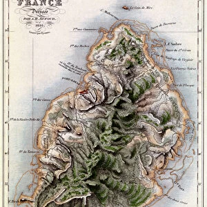
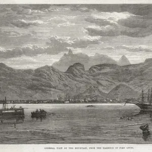
Map of Isle de France, Mauritius by Jacques-Nicolas Bellin, 1703-1772, from Atlas Maritime, engraving, 1763

![]()
Wall Art and Photo Gifts from Universal Images Group (UIG)
Map of Isle de France, Mauritius by Jacques-Nicolas Bellin, 1703-1772, from Atlas Maritime, engraving, 1763
Cartography, 18th century. Map of Isle de France (Mauritius), engraving by Jacques-Nicolas Bellin (1703-1772), from Atlas Maritime, 1763
Universal Images Group (UIG) manages distribution for many leading specialist agencies worldwide
Media ID 9504971
© DEA PICTURE LIBRARY
18th Century Coastline Illustration Technique Western Script Non Urban Scene
FEATURES IN THESE COLLECTIONS
> Animals
> Mammals
> Cercopithecidae
> Mauritius
> Universal Images Group (UIG)
> Art
> Painting, Sculpture & Prints
> Cartography
EDITORS COMMENTS
This print showcases a historical treasure - the Map of Isle de France, Mauritius by Jacques-Nicolas Bellin. Created between 1703 and 1772, this engraving from Atlas Maritime in 1763 is a testament to the artistry and precision of cartography in the 18th century. The map itself is a fascinating glimpse into the past, offering insights into physical geography and coastal features of Isle de France (Mauritius). With its horizontal layout and Western script, it effortlessly transports us back to an era when exploration was at its peak. In this studio shot, we see the engraved image displayed elegantly against a neutral background. The illustration technique employed by Bellin brings out intricate details of coastlines and landmarks with remarkable accuracy. As we admire this piece, devoid of any human presence, we are reminded of travel destinations that have stood the test of time. It serves as both an educational tool for history enthusiasts and an exquisite work of art for those who appreciate fine craftsmanship. This photograph from Universal Images Group (UIG) allows us to delve into our collective past while marveling at how far cartography has come since then. Let it transport you on a visual journey through time as you explore the rich history encapsulated within this Map of Isle de France by Jacques-Nicolas Bellin.
MADE IN THE UK
Safe Shipping with 30 Day Money Back Guarantee
FREE PERSONALISATION*
We are proud to offer a range of customisation features including Personalised Captions, Color Filters and Picture Zoom Tools
SECURE PAYMENTS
We happily accept a wide range of payment options so you can pay for the things you need in the way that is most convenient for you
* Options may vary by product and licensing agreement. Zoomed Pictures can be adjusted in the Basket.